Hinesburg geodata
Hinesburg (Vermont) is a populated place; located in United States in America/New_York (GMT-4) time zone. With population of 4,441 people, there are 7701 cities with bigger population in this country. Compared to other cities in United States, 89.8% of cities are located further ↓South; 93.7% of cities are located further ←West and 69.4% of cities have higher elevation than Hinesburg. Note1


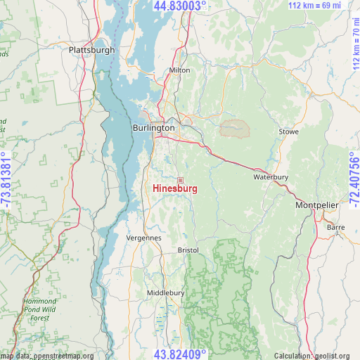
Hinesburg GPS coordinates[2]
44° 19' 45.192" North, 73° 6' 38.448" West
| Map corner | latitude | longitude |
|---|---|---|
| Upper-left | 44.83003°, | -73.81381° |
| Center: | 44.32922°, | -73.11068° |
| Lower-right: | 43.82409°, | -72.40756° |
| Map W x H: | 111.9×111.8 km | = 69.5×69.5mi |
| max Lat: | 71.29058° ⇑10.2% North |
| Hinesburg: | 44.32922° |
| min Lat: | ⇓89.8% South 19.06759° |
| min Long | Hinesburg | max Long |
| -171.73463° | -73.11068° | -66.98998° |
| W 93.7%⇐ | ⇒6.3% E |
Elevation
Elevation of Hinesburg is 104 m = 341 ft, and this is 190.8 m = 626 ft below average elevation for this country.
| Max E: |
3189 m = 10463 ft | 69.4% |
| Avg. | 294.8 m = 967 ft | |
| Hinesburg | 104 m = 341 ft | |
Min E: |
-60 m = -197 ft | 30.6% |
See also: United States elevation on elevation.city.
Geographical zone
Hinesburg is located in North temperate zone (between Tropic of Cancer and the Arctic Circle). Distance of this Northern Tropic circle is 2323 km =1443.4 mi to South.| Distance of | km | miles | from Hinesburg |
|---|---|---|---|
| North Pole | 5078.1 | 3155.4 | to North |
| Arctic Circle | 2472.2 | 1536.2 | to North |
| Tropic Cancer | 2323 | 1443.4 | to South |
| Equator | 4928.9 | 3062.7 | to South |


Nearby cities:
15 places around Hinesburg: (largest is in red/bold)
• Bristol
21.9 km =13.6 mi,  173°
173°
• Burlington
18.2 km =11.3 mi,  333°
333°
• Charlotte
12.1 km =7.5 mi,  259°
259°
• Colchester
24.1 km =15 mi,  352°
352°
• Essex Junction
17.9 km =11.1 mi,  359°
359°
• Ferrisburgh
17.5 km =10.9 mi,  218°
218°
• Jericho
21.4 km =13.3 mi,  24°
24°
• Richmond
12.6 km =7.8 mi,  47°
47°
• Shelburne
10.9 km =6.8 mi,  301°
301°
• South Burlington
16 km =9.9 mi,  342°
342°
• Starksboro
12.1 km =7.5 mi,  159°
159°
• Vergennes
21.3 km =13.2 mi,  212°
212°
• Williston
12.5 km =7.8 mi, 15°
• Willsboro
22.6 km =14 mi,  277°
277°
• Winooski
19 km =11.8 mi, 341°
Sources, notices
• [Note1] Compared only with cities in United States existing in our database
• [Src1] Map data: © OpenStreetMap contributors (CC-BY-SA)
• [Src2] Other city data from geonames.org with taken over terms of usage.
• [Src3] Geographical zone / Annual Mean Temperature by Robert A. Rohde @ Wikipedia
