Burlington geodata
Burlington (Vermont) is a seat of a second-order administrative division; located in United States in America/New_York (GMT-4) time zone. With population of 42,452 people, there are 1129 cities with bigger population in this country. Compared to other cities in United States, 90.3% of cities are located further ↓South; 93.4% of cities are located further ←West and 76.9% of cities have higher elevation than Burlington. Note1


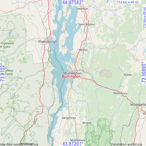
Burlington GPS coordinates[2]
44° 28' 33.168" North, 73° 12' 43.452" West
| Map corner | latitude | longitude |
|---|---|---|
| Upper-left | 44.97543°, | -73.9152° |
| Center: | 44.47588°, | -73.21207° |
| Lower-right: | 43.97201°, | -72.50895° |
| Map W x H: | 111.6×111.6 km | = 69.3×69.3mi |
| max Lat: | 71.29058° ⇑9.7% North |
| Burlington: | 44.47588° |
| min Lat: | ⇓90.3% South 19.06759° |
| min Long | Burlington | max Long |
| -171.73463° | -73.21207° | -66.98998° |
| W 93.4%⇐ | ⇒6.6% E |
Elevation
Elevation of Burlington is 61 m = 200 ft, and this is 233.8 m = 767 ft below average elevation for this country.
| Max E: |
3189 m = 10463 ft | 76.9% |
| Avg. | 294.8 m = 967 ft | |
| Burlington | 61 m = 200 ft | |
Min E: |
-60 m = -197 ft | 23.1% |
See also: Burlington elevation on elevation.city.
Geographical zone
Burlington is located in North temperate zone (between Tropic of Cancer and the Arctic Circle). Distance of this Northern Tropic circle is 2339.3 km =1453.6 mi to South.| Distance of | km | miles | from Burlington |
|---|---|---|---|
| North Pole | 5061.8 | 3145.3 | to North |
| Arctic Circle | 2455.9 | 1526 | to North |
| Tropic Cancer | 2339.3 | 1453.6 | to South |
| Equator | 4945.3 | 3072.9 | to South |


Nearby cities:
15 places around Burlington: (largest is in red/bold)
• Charlotte
18.9 km =11.7 mi,  191°
191°
• Colchester
9.1 km =5.7 mi,  33°
33°
• Essex Junction
8.2 km =5.1 mi,  78°
78°
• Ferrisburgh
30.2 km =18.8 mi, 185°
• Hinesburg
18.2 km =11.3 mi,  153°
153°
• Jericho
17.3 km =10.7 mi, 79°
• Keeseville
21.5 km =13.4 mi,  278°
278°
• Milton
19.9 km =12.4 mi,  23°
23°
• Peru
27.4 km =17 mi,  294°
294°
• Richmond
19.1 km =11.9 mi,  114°
114°
• Shelburne
10.7 km =6.6 mi, 186°
• South Burlington
3.4 km =2.1 mi, 106°
• Williston
12.2 km =7.6 mi, 110°
• Willsboro
19.4 km =12.1 mi,  227°
227°
• Winooski
2.7 km =1.7 mi,  50°
50°
Sources, notices
• [Note1] Compared only with cities in United States existing in our database
• [Src1] Map data: © OpenStreetMap contributors (CC-BY-SA)
• [Src2] Other city data from geonames.org with taken over terms of usage.
• [Src3] Geographical zone / Annual Mean Temperature by Robert A. Rohde @ Wikipedia
