Augusta geodata
Augusta (Wisconsin) is a populated place; located in United States in America/Chicago (GMT-5) time zone. With population of 1,532 people, there are 13537 cities with bigger population in this country. Compared to other cities in United States, 91.2% of cities are located further ↓South; 62.3% of cities are located further →East and 70.9% of cities have lower elevation than Augusta. Note1


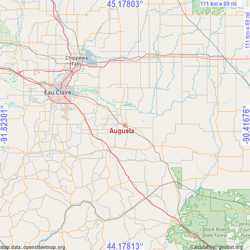
Augusta GPS coordinates[2]
44° 40' 48.864" North, 91° 7' 11.568" West
| Map corner | latitude | longitude |
|---|---|---|
| Upper-left | 45.17803°, | -91.82301° |
| Center: | 44.68024°, | -91.11988° |
| Lower-right: | 44.17813°, | -90.41676° |
| Map W x H: | 111.2×111.2 km | = 69.1×69.1mi |
| max Lat: | 71.29058° ⇑8.8% North |
| Augusta: | 44.68024° |
| min Lat: | ⇓91.2% South 19.06759° |
| min Long | Augusta | max Long |
| -171.73463° | -91.11988° | -66.98998° |
| W 37.7%⇐ | ⇒62.3% E |
Elevation
Elevation of Augusta is 290 m = 951 ft, and this is 4.8 m = 16 ft below average elevation for this country.
| Max E: |
3189 m = 10463 ft | 29.1% |
| Avg. | 294.8 m = 967 ft | |
| Augusta | 290 m = 951 ft | |
Min E: |
-60 m = -197 ft | 70.9% |
See also: United States elevation on elevation.city.
Geographical zone
Augusta is located in North temperate zone (between Tropic of Cancer and the Arctic Circle). Distance of this Northern Tropic circle is 2362.1 km =1467.7 mi to South.| Distance of | km | miles | from Augusta |
|---|---|---|---|
| North Pole | 5039.1 | 3131.2 | to North |
| Arctic Circle | 2433.2 | 1511.9 | to North |
| Tropic Cancer | 2362.1 | 1467.7 | to South |
| Equator | 4968 | 3087 | to South |


Nearby cities:
15 places around Augusta: (largest is in red/bold)
• Altoona
29 km =18 mi,  298°
298°
• Boyd
30.9 km =19.2 mi,  12°
12°
• Cadott
29.9 km =18.6 mi,  355°
355°
• Chippewa Falls
35.8 km =22.2 mi,  322°
322°
• Eau Claire
33.3 km =20.7 mi, 295°
• Eleva
30.1 km =18.7 mi,  247°
247°
• Fairchild
15.3 km =9.5 mi,  125°
125°
• Fall Creek
15.5 km =9.6 mi,  306°
306°
• Lake Hallie
33.4 km =20.8 mi, 310°
• Lake Wissota
30.9 km =19.2 mi,  332°
332°
• Merrillan
33.7 km =20.9 mi,  139°
139°
• Osseo
14.7 km =9.1 mi,  215°
215°
• Seymour
29.5 km =18.3 mi, 303°
• Stanley
34.3 km =21.3 mi,  24°
24°
• Strum
26 km =16.2 mi,  236°
236°
Sources, notices
• [Note1] Compared only with cities in United States existing in our database
• [Src1] Map data: © OpenStreetMap contributors (CC-BY-SA)
• [Src2] Other city data from geonames.org with taken over terms of usage.
• [Src3] Geographical zone / Annual Mean Temperature by Robert A. Rohde @ Wikipedia
