Lake Hallie geodata
Lake Hallie (Wisconsin) is a populated place; located in United States in America/Chicago (GMT-5) time zone. With population of 6,535 people, there are 6089 cities with bigger population in this country. Compared to other cities in United States, 91.9% of cities are located further ↓South; 63% of cities are located further →East and 67% of cities have lower elevation than Lake Hallie. Note1
Administrative division(s):
- Level 1: Wisconsin
- Level 2: Chippewa County
- Level 3: Village of Lake Hallie


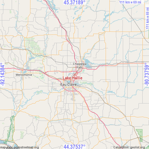
Lake Hallie GPS coordinates[2]
44° 52' 32.844" North, 91° 26' 26.556" West
| Map corner | latitude | longitude |
|---|---|---|
| Upper-left | 45.37189°, | -92.14384° |
| Center: | 44.87579°, | -91.44071° |
| Lower-right: | 44.37537°, | -90.73759° |
| Map W x H: | 110.8×110.8 km | = 68.8×68.8mi |
| max Lat: | 71.29058° ⇑8.1% North |
| Lake Hallie: | 44.87579° |
| min Lat: | ⇓91.9% South 19.06759° |
| min Long | Lake Hallie | max Long |
| -171.73463° | -91.44071° | -66.98998° |
| W 37%⇐ | ⇒63% E |
Elevation
Elevation of Lake Hallie is 271 m = 889 ft, and this is 23.8 m = 78 ft below average elevation for this country.
| Max E: |
3189 m = 10463 ft | 33% |
| Avg. | 294.8 m = 967 ft | |
| Lake Hallie | 271 m = 889 ft | |
Min E: |
-60 m = -197 ft | 67% |
See also: United States elevation on elevation.city.
Geographical zone
Lake Hallie is located in North temperate zone (between Tropic of Cancer and the Arctic Circle). Distance of this Northern Tropic circle is 2383.8 km =1481.2 mi to South.| Distance of | km | miles | from Lake Hallie |
|---|---|---|---|
| North Pole | 5017.3 | 3117.6 | to North |
| Arctic Circle | 2411.5 | 1498.4 | to North |
| Tropic Cancer | 2383.8 | 1481.2 | to South |
| Equator | 4989.7 | 3100.5 | to South |


Nearby cities:
15 places around Lake Hallie: (largest is in red/bold)
• Altoona
7.9 km =4.9 mi,  181°
181°
• Augusta
33.4 km =20.8 mi,  130°
130°
• Bloomer
25.2 km =15.7 mi,  351°
351°
• Boyd
33.1 km =20.6 mi,  75°
75°
• Cadott
24.2 km =15 mi,  70°
70°
• Chippewa Falls
7.8 km =4.8 mi,  28°
28°
• Colfax
26.3 km =16.3 mi,  300°
300°
• Eau Claire
8.5 km =5.3 mi,  212°
212°
• Eleva
33.4 km =20.8 mi, 183°
• Elk Mound
19.7 km =12.2 mi,  269°
269°
• Fall Creek
18 km =11.2 mi, 134°
• Lake Wissota
12.4 km =7.7 mi,  62°
62°
• Seymour
5.5 km =3.4 mi,  172°
172°
• Strum
36.5 km =22.7 mi, 174°
• Tainter Lake
34.4 km =21.4 mi,  291°
291°
Sources, notices
• [Note1] Compared only with cities in United States existing in our database
• [Src1] Map data: © OpenStreetMap contributors (CC-BY-SA)
• [Src2] Other city data from geonames.org with taken over terms of usage.
• [Src3] Geographical zone / Annual Mean Temperature by Robert A. Rohde @ Wikipedia
