Bristol geodata
Bristol (Wisconsin) is a populated place; located in United States in America/Chicago (GMT-5) time zone. With population of 4,951 people, there are 7229 cities with bigger population in this country. Compared to other cities in United States, 80.2% of cities are located further ↓South; 53.1% of cities are located further →East and 60.1% of cities have lower elevation than Bristol. Note1


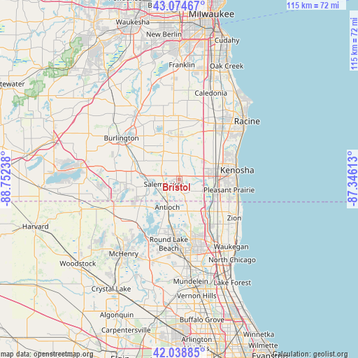
Bristol GPS coordinates[2]
42° 33' 32.076" North, 88° 2' 57.3" West
| Map corner | latitude | longitude |
|---|---|---|
| Upper-left | 43.07467°, | -88.75238° |
| Center: | 42.55891°, | -88.04925° |
| Lower-right: | 42.03885°, | -87.34613° |
| Map W x H: | 115.2×115.2 km | = 71.6×71.6mi |
| max Lat: | 71.29058° ⇑19.8% North |
| Bristol: | 42.55891° |
| min Lat: | ⇓80.2% South 19.06759° |
| min Long | Bristol | max Long |
| -171.73463° | -88.04925° | -66.98998° |
| W 46.9%⇐ | ⇒53.1% E |
Elevation
Elevation of Bristol is 240 m = 787 ft, and this is 54.8 m = 180 ft below average elevation for this country.
| Max E: |
3189 m = 10463 ft | 39.9% |
| Avg. | 294.8 m = 967 ft | |
| Bristol | 240 m = 787 ft | |
Min E: |
-60 m = -197 ft | 60.1% |
See also: United States elevation on elevation.city.
Geographical zone
Bristol is located in North temperate zone (between Tropic of Cancer and the Arctic Circle). Distance of this Northern Tropic circle is 2126.2 km =1321.2 mi to South.| Distance of | km | miles | from Bristol |
|---|---|---|---|
| North Pole | 5275 | 3277.7 | to North |
| Arctic Circle | 2669.1 | 1658.5 | to North |
| Tropic Cancer | 2126.2 | 1321.2 | to South |
| Equator | 4732.1 | 2940.4 | to South |


Nearby cities:
15 places around Bristol: (largest is in red/bold)
• Antioch
9.8 km =6.1 mi,  202°
202°
• Camp Lake
8.2 km =5.1 mi,  250°
250°
• Channel Lake
11.5 km =7.1 mi,  219°
219°
• Eagle Lake
17.7 km =11 mi,  338°
338°
• Lake Catherine
11.2 km =7 mi, 217°
• Lake Shangrila
6.2 km =3.9 mi, 196°
• Lake Villa
15.9 km =9.9 mi,  187°
187°
• Lindenhurst
16.6 km =10.3 mi,  173°
173°
• Paddock Lake
5 km =3.1 mi,  294°
294°
• Pleasant Prairie
9.5 km =5.9 mi,  93°
93°
• Salem
5.1 km =3.2 mi,  264°
264°
• Silver Lake
9.6 km =6 mi, 261°
• Somers
14.5 km =9 mi,  51°
51°
• Twin Lakes
16.6 km =10.3 mi, 259°
• Union Grove
14.4 km =8.9 mi,  359°
359°
Sources, notices
• [Note1] Compared only with cities in United States existing in our database
• [Src1] Map data: © OpenStreetMap contributors (CC-BY-SA)
• [Src2] Other city data from geonames.org with taken over terms of usage.
• [Src3] Geographical zone / Annual Mean Temperature by Robert A. Rohde @ Wikipedia
