Pleasant Prairie geodata
Pleasant Prairie (Wisconsin) is a populated place; located in United States in America/Chicago (GMT-5) time zone. With population of 20,726 people, there are 2434 cities with bigger population in this country. Compared to other cities in United States, 80.2% of cities are located further ↓South; 52.6% of cities are located further →East and 53.9% of cities have lower elevation than Pleasant Prairie. Note1
Administrative division(s):
- Level 1: Wisconsin
- Level 2: Kenosha County
- Level 3: Village of Pleasant Prairie


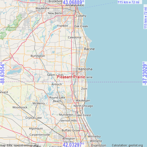
Pleasant Prairie GPS coordinates[2]
42° 33' 11.088" North, 87° 56' 0.276" West
| Map corner | latitude | longitude |
|---|---|---|
| Upper-left | 43.06889°, | -88.63654° |
| Center: | 42.55308°, | -87.93341° |
| Lower-right: | 42.03297°, | -87.23029° |
| Map W x H: | 115.2×115.2 km | = 71.6×71.6mi |
| max Lat: | 71.29058° ⇑19.8% North |
| Pleasant Prairie: | 42.55308° |
| min Lat: | ⇓80.2% South 19.06759° |
| min Long | Pleasant Prairi | max Long |
| -171.73463° | -87.93341° | -66.98998° |
| W 47.4%⇐ | ⇒52.6% E |
Elevation
Elevation of Pleasant Prairie is 214 m = 702 ft, and this is 80.8 m = 265 ft below average elevation for this country.
| Max E: |
3189 m = 10463 ft | 46.1% |
| Avg. | 294.8 m = 967 ft | |
| Pleasant Prairie | 214 m = 702 ft | |
Min E: |
-60 m = -197 ft | 53.9% |
See also: United States elevation on elevation.city.
Geographical zone
Pleasant Prairie is located in North temperate zone (between Tropic of Cancer and the Arctic Circle). Distance of this Northern Tropic circle is 2125.5 km =1320.7 mi to South.| Distance of | km | miles | from Pleasant Prairie |
|---|---|---|---|
| North Pole | 5275.6 | 3278.1 | to North |
| Arctic Circle | 2669.7 | 1658.9 | to North |
| Tropic Cancer | 2125.5 | 1320.7 | to South |
| Equator | 4731.5 | 2940 | to South |


Nearby cities:
15 places around Pleasant Prairie: (largest is in red/bold)
• Antioch
15.7 km =9.8 mi,  237°
237°
• Beach Park
15.8 km =9.8 mi,  156°
156°
• Bristol
9.5 km =5.9 mi,  273°
273°
• Camp Lake
17.3 km =10.7 mi,  263°
263°
• Kenosha
9.8 km =6.1 mi,  69°
69°
• Lake Shangrila
12.4 km =7.7 mi, 244°
• Lindenhurst
17.6 km =10.9 mi,  205°
205°
• Mount Pleasant
17.3 km =10.7 mi,  21°
21°
• Paddock Lake
14.3 km =8.9 mi,  280°
280°
• Salem
14.5 km =9 mi, 270°
• Somers
9.9 km =6.2 mi,  11°
11°
• Sturtevant
16.4 km =10.2 mi, 11°
• Wadsworth
13.9 km =8.6 mi,  176°
176°
• Winthrop Harbor
12.2 km =7.6 mi,  132°
132°
• Zion
14.5 km =9 mi,  145°
145°
Sources, notices
• [Note1] Compared only with cities in United States existing in our database
• [Src1] Map data: © OpenStreetMap contributors (CC-BY-SA)
• [Src2] Other city data from geonames.org with taken over terms of usage.
• [Src3] Geographical zone / Annual Mean Temperature by Robert A. Rohde @ Wikipedia
