Howards Grove geodata
Howards Grove (Wisconsin) is a populated place; located in United States in America/Chicago (GMT-5) time zone. With population of 3,271 people, there are 9195 cities with bigger population in this country. Compared to other cities in United States, 87.7% of cities are located further ↓South; 52% of cities are located further →East and 55.1% of cities have lower elevation than Howards Grove. Note1
Administrative division(s):
- Level 1: Wisconsin
- Level 2: Sheboygan County
- Level 3: Village of Howards Grove


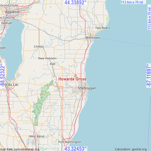
Howards Grove GPS coordinates[2]
43° 50' 1.968" North, 87° 49' 12.324" West
| Map corner | latitude | longitude |
|---|---|---|
| Upper-left | 44.33892°, | -88.52322° |
| Center: | 43.83388°, | -87.82009° |
| Lower-right: | 43.32453°, | -87.11697° |
| Map W x H: | 112.8×112.8 km | = 70.1×70.1mi |
| max Lat: | 71.29058° ⇑12.3% North |
| Howards Grove: | 43.83388° |
| min Lat: | ⇓87.7% South 19.06759° |
| min Long | Howards Grove | max Long |
| -171.73463° | -87.82009° | -66.98998° |
| W 48%⇐ | ⇒52% E |
Elevation
Elevation of Howards Grove is 219 m = 719 ft, and this is 75.8 m = 249 ft below average elevation for this country.
| Max E: |
3189 m = 10463 ft | 44.9% |
| Avg. | 294.8 m = 967 ft | |
| Howards Grove | 219 m = 719 ft | |
Min E: |
-60 m = -197 ft | 55.1% |
See also: United States elevation on elevation.city.
Geographical zone
Howards Grove is located in North temperate zone (between Tropic of Cancer and the Arctic Circle). Distance of this Northern Tropic circle is 2268 km =1409.3 mi to South.| Distance of | km | miles | from Howards Grove |
|---|---|---|---|
| North Pole | 5133.2 | 3189.6 | to North |
| Arctic Circle | 2527.3 | 1570.4 | to North |
| Tropic Cancer | 2268 | 1409.3 | to South |
| Equator | 4873.9 | 3028.5 | to South |


Nearby cities:
15 places around Howards Grove: (largest is in red/bold)
• Adell
26.1 km =16.2 mi,  203°
203°
• Cascade
24.6 km =15.3 mi,  217°
217°
• Cleveland
10.7 km =6.6 mi,  32°
32°
• Elkhart Lake
15.9 km =9.9 mi,  269°
269°
• Gibbsville
20.2 km =12.6 mi,  181°
181°
• Hingham
23 km =14.3 mi, 199°
• Kiel
19.4 km =12.1 mi,  296°
296°
• Kohler
11 km =6.8 mi,  163°
163°
• New Holstein
24.8 km =15.4 mi, 301°
• Oostburg
23.6 km =14.7 mi,  174°
174°
• Plymouth
15.8 km =9.8 mi,  233°
233°
• Saint Nazianz
21 km =13 mi,  337°
337°
• Sheboygan
12.5 km =7.8 mi,  137°
137°
• Sheboygan Falls
11.3 km =7 mi, 180°
• Valders
26.3 km =16.3 mi,  348°
348°
Sources, notices
• [Note1] Compared only with cities in United States existing in our database
• [Src1] Map data: © OpenStreetMap contributors (CC-BY-SA)
• [Src2] Other city data from geonames.org with taken over terms of usage.
• [Src3] Geographical zone / Annual Mean Temperature by Robert A. Rohde @ Wikipedia
