Sheboygan geodata
Sheboygan (Wisconsin) is a seat of a second-order administrative division; located in United States in America/Chicago (GMT-5) time zone. With population of 48,797 people, there are 983 cities with bigger population in this country. Compared to other cities in United States, 87.4% of cities are located further ↓South; 51.6% of cities are located further →East and 51.4% of cities have higher elevation than Sheboygan. Note1


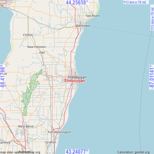
Sheboygan GPS coordinates[2]
43° 45' 2.988" North, 87° 42' 52.308" West
| Map corner | latitude | longitude |
|---|---|---|
| Upper-left | 44.25658°, | -88.41766° |
| Center: | 43.75083°, | -87.71453° |
| Lower-right: | 43.24077°, | -87.01141° |
| Map W x H: | 112.9×112.9 km | = 70.2×70.2mi |
| max Lat: | 71.29058° ⇑12.6% North |
| Sheboygan: | 43.75083° |
| min Lat: | ⇓87.4% South 19.06759° |
| min Long | Sheboygan | max Long |
| -171.73463° | -87.71453° | -66.98998° |
| W 48.4%⇐ | ⇒51.6% E |
Elevation
Elevation of Sheboygan is 193 m = 633 ft, and this is 101.8 m = 334 ft below average elevation for this country.
| Max E: |
3189 m = 10463 ft | 51.4% |
| Avg. | 294.8 m = 967 ft | |
| Sheboygan | 193 m = 633 ft | |
Min E: |
-60 m = -197 ft | 48.6% |
See also: Sheboygan elevation on elevation.city.
Geographical zone
Sheboygan is located in North temperate zone (between Tropic of Cancer and the Arctic Circle). Distance of this Northern Tropic circle is 2258.7 km =1403.5 mi to South.| Distance of | km | miles | from Sheboygan |
|---|---|---|---|
| North Pole | 5142.4 | 3195.3 | to North |
| Arctic Circle | 2536.5 | 1576.1 | to North |
| Tropic Cancer | 2258.7 | 1403.5 | to South |
| Equator | 4864.6 | 3022.7 | to South |


Nearby cities:
15 places around Sheboygan: (largest is in red/bold)
• Adell
24.1 km =15 mi,  232°
232°
• Belgium
30 km =18.6 mi,  201°
201°
• Cascade
25.7 km =16 mi,  246°
246°
• Cedar Grove
22 km =13.7 mi, 203°
• Cleveland
18.4 km =11.4 mi,  351°
351°
• Elkhart Lake
26 km =16.2 mi,  290°
290°
• Gibbsville
14.2 km =8.8 mi,  219°
219°
• Hingham
20.3 km =12.6 mi, 232°
• Howards Grove
12.5 km =7.8 mi,  317°
317°
• Kiel
31.4 km =19.5 mi,  304°
304°
• Kohler
5.6 km =3.5 mi,  256°
256°
• Oostburg
15.6 km =9.7 mi, 204°
• Plymouth
21.1 km =13.1 mi,  269°
269°
• Random Lake
29.7 km =18.5 mi, 222°
• Sheboygan Falls
8.9 km =5.5 mi, 256°
Sources, notices
• [Note1] Compared only with cities in United States existing in our database
• [Src1] Map data: © OpenStreetMap contributors (CC-BY-SA)
• [Src2] Other city data from geonames.org with taken over terms of usage.
• [Src3] Geographical zone / Annual Mean Temperature by Robert A. Rohde @ Wikipedia
