Lamartine geodata
Lamartine (Wisconsin) is a populated place; located in United States in America/Chicago (GMT-5) time zone. With population of 1,727 people, there are 12822 cities with bigger population in this country. Compared to other cities in United States, 87.4% of cities are located further ↓South; 55% of cities are located further →East and 66.6% of cities have lower elevation than Lamartine. Note1
Administrative division(s):
- Level 1: Wisconsin
- Level 2: Fond du Lac County
- Level 3: Town of Lamartine


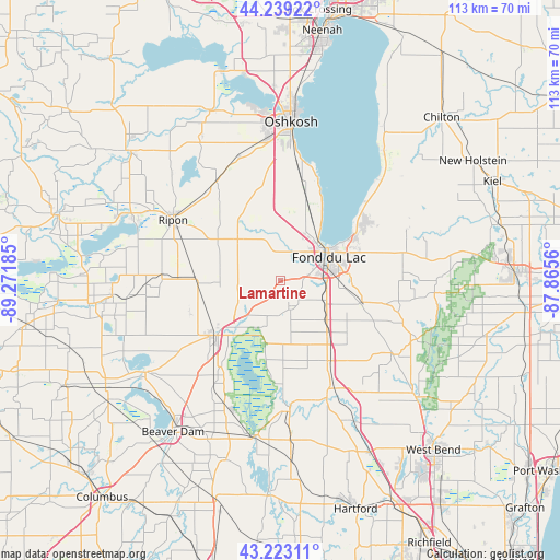
Lamartine GPS coordinates[2]
43° 43' 59.952" North, 88° 34' 7.392" West
| Map corner | latitude | longitude |
|---|---|---|
| Upper-left | 44.23922°, | -89.27185° |
| Center: | 43.73332°, | -88.56872° |
| Lower-right: | 43.22311°, | -87.8656° |
| Map W x H: | 113×113 km | = 70.2×70.2mi |
| max Lat: | 71.29058° ⇑12.6% North |
| Lamartine: | 43.73332° |
| min Lat: | ⇓87.4% South 19.06759° |
| min Long | Lamartine | max Long |
| -171.73463° | -88.56872° | -66.98998° |
| W 45%⇐ | ⇒55% E |
Elevation
Elevation of Lamartine is 269 m = 883 ft, and this is 25.8 m = 85 ft below average elevation for this country.
| Max E: |
3189 m = 10463 ft | 33.4% |
| Avg. | 294.8 m = 967 ft | |
| Lamartine | 269 m = 883 ft | |
Min E: |
-60 m = -197 ft | 66.6% |
See also: United States elevation on elevation.city.
Geographical zone
Lamartine is located in North temperate zone (between Tropic of Cancer and the Arctic Circle). Distance of this Northern Tropic circle is 2256.8 km =1402.3 mi to South.| Distance of | km | miles | from Lamartine |
|---|---|---|---|
| North Pole | 5144.4 | 3196.6 | to North |
| Arctic Circle | 2538.5 | 1577.4 | to North |
| Tropic Cancer | 2256.8 | 1402.3 | to South |
| Equator | 4862.7 | 3021.5 | to South |


Nearby cities:
15 places around Lamartine: (largest is in red/bold)
• Alto
19.3 km =12 mi,  250°
250°
• Ashford
22.8 km =14.2 mi,  135°
135°
• Brandon
17.1 km =10.6 mi,  270°
270°
• Brownsville
14.4 km =8.9 mi,  154°
154°
• Eden
17.3 km =10.7 mi,  104°
104°
• Eldorado
11 km =6.8 mi,  337°
337°
• Fond du Lac
11.4 km =7.1 mi,  66°
66°
• Lomira
18.7 km =11.6 mi, 147°
• North Fond du Lac
11.1 km =6.9 mi,  38°
38°
• Oakfield
5.5 km =3.4 mi,  161°
161°
• Ripon
24.6 km =15.3 mi,  299°
299°
• Rosendale
11.9 km =7.4 mi,  314°
314°
• Saint Peter
21.5 km =13.4 mi,  57°
57°
• Taycheedah
16.3 km =10.1 mi, 58°
• Waupun
17.1 km =10.6 mi,  229°
229°
Sources, notices
• [Note1] Compared only with cities in United States existing in our database
• [Src1] Map data: © OpenStreetMap contributors (CC-BY-SA)
• [Src2] Other city data from geonames.org with taken over terms of usage.
• [Src3] Geographical zone / Annual Mean Temperature by Robert A. Rohde @ Wikipedia
