Lomira geodata
Lomira (Wisconsin) is a populated place; located in United States in America/Chicago (GMT-5) time zone. With population of 2,384 people, there are 10890 cities with bigger population in this country. Compared to other cities in United States, 86.7% of cities are located further ↓South; 54.6% of cities are located further →East and 76.4% of cities have lower elevation than Lomira. Note1


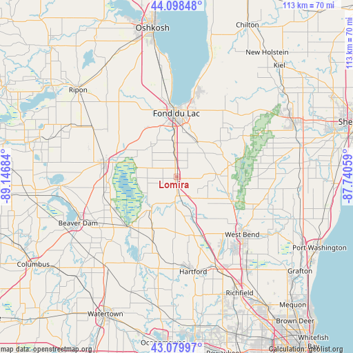
Lomira GPS coordinates[2]
43° 35' 28.968" North, 88° 26' 37.356" West
| Map corner | latitude | longitude |
|---|---|---|
| Upper-left | 44.09848°, | -89.14684° |
| Center: | 43.59138°, | -88.44371° |
| Lower-right: | 43.07997°, | -87.74059° |
| Map W x H: | 113.2×113.2 km | = 70.3×70.3mi |
| max Lat: | 71.29058° ⇑13.3% North |
| Lomira: | 43.59138° |
| min Lat: | ⇓86.7% South 19.06759° |
| min Long | Lomira | max Long |
| -171.73463° | -88.44371° | -66.98998° |
| W 45.4%⇐ | ⇒54.6% E |
Elevation
Elevation of Lomira is 323 m = 1060 ft, and this is 28.2 m = 93 ft above average elevation for this country.
| Max E: |
3189 m = 10463 ft | 23.6% |
| Lomira | 323 m 1060 ft | |
| Avg. | 294.8 m = 967 ft | |
Min E: |
-60 m = -197 ft | 76.4% |
See also: United States elevation on elevation.city.
Geographical zone
Lomira is located in North temperate zone (between Tropic of Cancer and the Arctic Circle). Distance of this Northern Tropic circle is 2241 km =1392.5 mi to South.| Distance of | km | miles | from Lomira |
|---|---|---|---|
| North Pole | 5160.2 | 3206.4 | to North |
| Arctic Circle | 2554.3 | 1587.2 | to North |
| Tropic Cancer | 2241 | 1392.5 | to South |
| Equator | 4846.9 | 3011.7 | to South |


Nearby cities:
15 places around Lomira: (largest is in red/bold)
• Addison
19.6 km =12.2 mi,  163°
163°
• Allenton
20.7 km =12.9 mi, 156°
• Ashford
5.9 km =3.7 mi,  94°
94°
• Brownsville
4.7 km =2.9 mi,  306°
306°
• Campbellsport
13.3 km =8.3 mi, 86°
• Eden
13.2 km =8.2 mi,  30°
30°
• Fond du Lac
20.4 km =12.7 mi,  1°
1°
• Horicon
21.7 km =13.5 mi,  224°
224°
• Iron Ridge
22.5 km =14 mi,  198°
198°
• Kewaskum
19 km =11.8 mi,  114°
114°
• Lamartine
18.7 km =11.6 mi,  327°
327°
• Mayville
13.5 km =8.4 mi, 217°
• Oakfield
13.4 km =8.3 mi,  321°
321°
• Theresa
8.3 km =5.2 mi,  184°
184°
• Waupun
23.5 km =14.6 mi,  281°
281°
Sources, notices
• [Note1] Compared only with cities in United States existing in our database
• [Src1] Map data: © OpenStreetMap contributors (CC-BY-SA)
• [Src2] Other city data from geonames.org with taken over terms of usage.
• [Src3] Geographical zone / Annual Mean Temperature by Robert A. Rohde @ Wikipedia
