Richfield geodata
Richfield (Wisconsin) is a populated place; located in United States in America/Chicago (GMT-5) time zone. With population of 11,530 people, there are 4018 cities with bigger population in this country. Compared to other cities in United States, 85.2% of cities are located further ↓South; 53.7% of cities are located further →East and 72.9% of cities have lower elevation than Richfield. Note1
Administrative division(s):
- Level 1: Wisconsin
- Level 2: Washington County
- Level 3: Village of Richfield


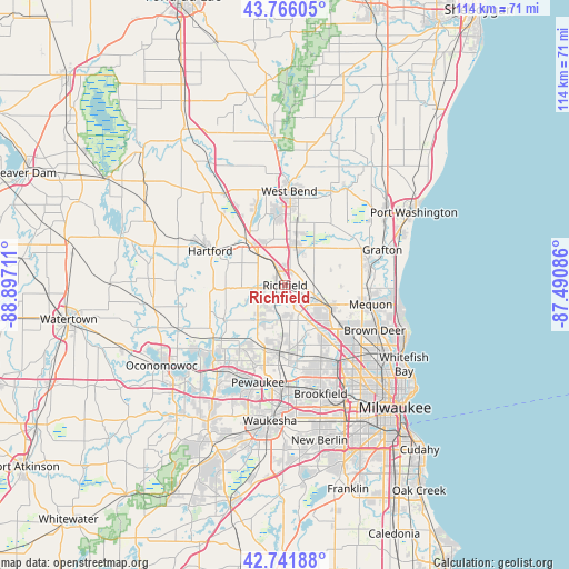
Richfield GPS coordinates[2]
43° 15' 22.032" North, 88° 11' 38.328" West
| Map corner | latitude | longitude |
|---|---|---|
| Upper-left | 43.76605°, | -88.89711° |
| Center: | 43.25612°, | -88.19398° |
| Lower-right: | 42.74188°, | -87.49086° |
| Map W x H: | 113.9×113.9 km | = 70.8×70.8mi |
| max Lat: | 71.29058° ⇑14.8% North |
| Richfield: | 43.25612° |
| min Lat: | ⇓85.2% South 19.06759° |
| min Long | Richfield | max Long |
| -171.73463° | -88.19398° | -66.98998° |
| W 46.3%⇐ | ⇒53.7% E |
Elevation
Elevation of Richfield is 301 m = 988 ft, and this is 6.2 m = 20 ft above average elevation for this country.
| Max E: |
3189 m = 10463 ft | 27.1% |
| Richfield | 301 m 988 ft | |
| Avg. | 294.8 m = 967 ft | |
Min E: |
-60 m = -197 ft | 72.9% |
See also: United States elevation on elevation.city.
Geographical zone
Richfield is located in North temperate zone (between Tropic of Cancer and the Arctic Circle). Distance of this Northern Tropic circle is 2203.7 km =1369.3 mi to South.| Distance of | km | miles | from Richfield |
|---|---|---|---|
| North Pole | 5197.4 | 3229.5 | to North |
| Arctic Circle | 2591.5 | 1610.3 | to North |
| Tropic Cancer | 2203.7 | 1369.3 | to South |
| Equator | 4809.6 | 2988.5 | to South |


Nearby cities:
15 places around Richfield: (largest is in red/bold)
• Butler
19.5 km =12.1 mi,  148°
148°
• Cedarburg
17.3 km =10.7 mi,  74°
74°
• Germantown
7.4 km =4.6 mi,  114°
114°
• Hartford
16.5 km =10.3 mi,  294°
294°
• Hartland
20.6 km =12.8 mi,  215°
215°
• Jackson
7.9 km =4.9 mi,  16°
16°
• Lannon
12.4 km =7.7 mi,  169°
169°
• Menomonee Falls
10.6 km =6.6 mi,  144°
144°
• Mequon
14 km =8.7 mi, 108°
• Merton
15.2 km =9.4 mi, 216°
• Pewaukee
20.3 km =12.6 mi,  195°
195°
• Slinger
11.4 km =7.1 mi,  319°
319°
• Sussex
13.8 km =8.6 mi,  189°
189°
• Thiensville
17.6 km =10.9 mi,  96°
96°
• West Bend
18.8 km =11.7 mi,  2°
2°
Sources, notices
• [Note1] Compared only with cities in United States existing in our database
• [Src1] Map data: © OpenStreetMap contributors (CC-BY-SA)
• [Src2] Other city data from geonames.org with taken over terms of usage.
• [Src3] Geographical zone / Annual Mean Temperature by Robert A. Rohde @ Wikipedia
