Jackson geodata
Jackson (Wisconsin) is a populated place; located in United States in America/Chicago (GMT-5) time zone. With population of 6,859 people, there are 5887 cities with bigger population in this country. Compared to other cities in United States, 85.5% of cities are located further ↓South; 53.6% of cities are located further →East and 67.8% of cities have lower elevation than Jackson. Note1
Administrative division(s):
- Level 1: Wisconsin
- Level 2: Washington County
- Level 3: Village of Jackson


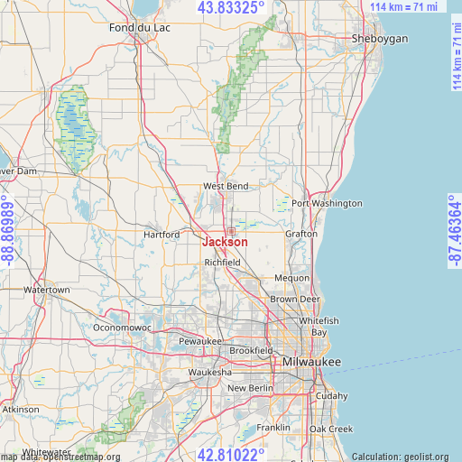
Jackson GPS coordinates[2]
43° 19' 26.004" North, 88° 10' 0.336" West
| Map corner | latitude | longitude |
|---|---|---|
| Upper-left | 43.83325°, | -88.86989° |
| Center: | 43.32389°, | -88.16676° |
| Lower-right: | 42.81022°, | -87.46364° |
| Map W x H: | 113.8×113.7 km | = 70.7×70.6mi |
| max Lat: | 71.29058° ⇑14.5% North |
| Jackson: | 43.32389° |
| min Lat: | ⇓85.5% South 19.06759° |
| min Long | Jackson | max Long |
| -171.73463° | -88.16676° | -66.98998° |
| W 46.4%⇐ | ⇒53.6% E |
Elevation
Elevation of Jackson is 275 m = 902 ft, and this is 19.8 m = 65 ft below average elevation for this country.
| Max E: |
3189 m = 10463 ft | 32.2% |
| Avg. | 294.8 m = 967 ft | |
| Jackson | 275 m = 902 ft | |
Min E: |
-60 m = -197 ft | 67.8% |
See also: United States elevation on elevation.city.
Geographical zone
Jackson is located in North temperate zone (between Tropic of Cancer and the Arctic Circle). Distance of this Northern Tropic circle is 2211.2 km =1374 mi to South.| Distance of | km | miles | from Jackson |
|---|---|---|---|
| North Pole | 5189.9 | 3224.9 | to North |
| Arctic Circle | 2584 | 1605.6 | to North |
| Tropic Cancer | 2211.2 | 1374 | to South |
| Equator | 4817.2 | 2993.3 | to South |


Nearby cities:
15 places around Jackson: (largest is in red/bold)
• Allenton
17.7 km =11 mi,  307°
307°
• Barton
13.4 km =8.3 mi,  355°
355°
• Cedarburg
14.8 km =9.2 mi,  101°
101°
• Germantown
11.5 km =7.1 mi,  156°
156°
• Grafton
17.3 km =10.7 mi,  91°
91°
• Hartford
17.2 km =10.7 mi,  267°
267°
• Lannon
19.8 km =12.3 mi,  179°
179°
• Menomonee Falls
16.6 km =10.3 mi,  166°
166°
• Mequon
16.4 km =10.2 mi,  137°
137°
• Newburg
15.4 km =9.6 mi,  39°
39°
• Richfield
7.9 km =4.9 mi,  196°
196°
• Saukville
19.4 km =12.1 mi,  70°
70°
• Slinger
9.7 km =6 mi,  276°
276°
• Thiensville
18 km =11.2 mi,  122°
122°
• West Bend
11.4 km =7.1 mi,  353°
353°
Sources, notices
• [Note1] Compared only with cities in United States existing in our database
• [Src1] Map data: © OpenStreetMap contributors (CC-BY-SA)
• [Src2] Other city data from geonames.org with taken over terms of usage.
• [Src3] Geographical zone / Annual Mean Temperature by Robert A. Rohde @ Wikipedia
