Siren geodata
Siren (Wisconsin) is a seat of a second-order administrative division; located in United States in America/Chicago (GMT-5) time zone. With population of 778 people, there are 17996 cities with bigger population in this country. Compared to other cities in United States, 94.7% of cities are located further ↓South; 64.9% of cities are located further →East and 73.3% of cities have lower elevation than Siren. Note1


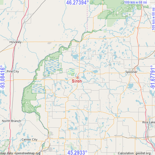
Siren GPS coordinates[2]
45° 47' 8.808" North, 92° 22' 51.708" West
| Map corner | latitude | longitude |
|---|---|---|
| Upper-left | 46.27394°, | -93.08416° |
| Center: | 45.78578°, | -92.38103° |
| Lower-right: | 45.2933°, | -91.67791° |
| Map W x H: | 109×109 km | = 67.7×67.7mi |
| max Lat: | 71.29058° ⇑5.3% North |
| Siren: | 45.78578° |
| min Lat: | ⇓94.7% South 19.06759° |
| min Long | Siren | max Long |
| -171.73463° | -92.38103° | -66.98998° |
| W 35.1%⇐ | ⇒64.9% E |
Elevation
Elevation of Siren is 303 m = 994 ft, and this is 8.2 m = 27 ft above average elevation for this country.
| Max E: |
3189 m = 10463 ft | 26.7% |
| Siren | 303 m 994 ft | |
| Avg. | 294.8 m = 967 ft | |
Min E: |
-60 m = -197 ft | 73.3% |
See also: United States elevation on elevation.city.
Geographical zone
Siren is located in North temperate zone (between Tropic of Cancer and the Arctic Circle). Distance of this North polar circle is 2310.3 km =1435.6 mi to North.| Distance of | km | miles | from Siren |
|---|---|---|---|
| North Pole | 4916.2 | 3054.8 | to North |
| Arctic Circle | 2310.3 | 1435.6 | to North |
| Tropic Cancer | 2485 | 1544.1 | to South |
| Equator | 5090.9 | 3163.3 | to South |


Nearby cities:
15 places around Siren: (largest is in red/bold)
• Balsam Lake
37.5 km =23.3 mi,  188°
188°
• Centuria
39.5 km =24.5 mi,  199°
199°
• Clam Falls
12.8 km =8 mi,  147°
147°
• Cumberland
39.8 km =24.7 mi,  135°
135°
• Frederic
15.6 km =9.7 mi,  205°
205°
• Grantsburg
23.4 km =14.5 mi,  267°
267°
• Luck
24.6 km =15.3 mi, 198°
• Milltown
30.5 km =19 mi, 198°
• Pine City
45.8 km =28.5 mi,  275°
275°
• Rock Creek
45.2 km =28.1 mi, 266°
• Rush City
46.7 km =29 mi,  256°
256°
• Saint Croix Falls
46.4 km =28.8 mi, 205°
• Shell Lake
35.7 km =22.2 mi,  98°
98°
• Spooner
38.3 km =23.8 mi,  83°
83°
• Webster
10.2 km =6.3 mi,  5°
5°
Sources, notices
• [Note1] Compared only with cities in United States existing in our database
• [Src1] Map data: © OpenStreetMap contributors (CC-BY-SA)
• [Src2] Other city data from geonames.org with taken over terms of usage.
• [Src3] Geographical zone / Annual Mean Temperature by Robert A. Rohde @ Wikipedia
