Nogales geodata
Nogales (Arizona) is a seat of a second-order administrative division; located in United States in America/Phoenix (GMT-7) time zone. With population of 20,252 people, there are 2483 cities with bigger population in this country. Compared to other cities in United States, 90% of cities are located further ↑North; 86.2% of cities are located further →East and 94.4% of cities have lower elevation than Nogales. Note1


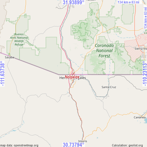
Nogales GPS coordinates[2]
31° 20' 25.368" North, 110° 56' 3.3" West
| Map corner | latitude | longitude |
|---|---|---|
| Upper-left | 31.93899°, | -111.63738° |
| Center: | 31.34038°, | -110.93425° |
| Lower-right: | 30.73794°, | -110.23113° |
| Map W x H: | 133.5×133.5 km | = 83×83mi |
| max Lat: | 71.29058° ⇑90% North |
| Nogales: | 31.34038° |
| min Lat: | ⇓10% South 19.06759° |
| min Long | Nogales | max Long |
| -171.73463° | -110.93425° | -66.98998° |
| W 13.8%⇐ | ⇒86.2% E |
Elevation
Elevation of Nogales is 1172 m = 3845 ft, and this is 877.2 m = 2878 ft above average elevation for this country.
| Max E: |
3189 m = 10463 ft | 5.6% |
| Nogales | 1172 m 3845 ft | |
| Avg. | 294.8 m = 967 ft | |
Min E: |
-60 m = -197 ft | 94.4% |
See also: United States elevation on elevation.city.
Geographical zone
Nogales is located in North temperate zone (between Tropic of Cancer and the Arctic Circle). Distance of this Northern Tropic circle is 878.8 km =546.1 mi to South.| Distance of | km | miles | from Nogales |
|---|---|---|---|
| North Pole | 6522.3 | 4052.8 | to North |
| Arctic Circle | 3916.5 | 2433.6 | to North |
| Tropic Cancer | 878.8 | 546.1 | to South |
| Equator | 3484.7 | 2165.3 | to South |


Nearby cities:
15 places around Nogales: (largest is in red/bold)
• Arivaca
45.9 km =28.5 mi,  304°
304°
• Arivaca Junction
44.7 km =27.8 mi,  344°
344°
• Corona de Tucson
71.1 km =44.2 mi,  12°
12°
• East Sahuarita
67 km =41.6 mi,  0°
0°
• Green Valley
57.4 km =35.7 mi,  354°
354°
• Huachuca City
65.3 km =40.6 mi,  60°
60°
• Miracle Valley
74.3 km =46.2 mi,  86°
86°
• Patagonia
27.9 km =17.3 mi,  37°
37°
• Rio Rico
15.1 km =9.4 mi, 344°
• Sahuarita
68.7 km =42.7 mi,  358°
358°
• Sierra Vista
64.4 km =40 mi,  68°
68°
• Sierra Vista Southeast
69.3 km =43.1 mi,  79°
79°
• Sonoita
46 km =28.6 mi,  34°
34°
• Tubac
32.1 km =19.9 mi, 340°
• Whetstone
69.2 km =43 mi,  54°
54°
Sources, notices
• [Note1] Compared only with cities in United States existing in our database
• [Src1] Map data: © OpenStreetMap contributors (CC-BY-SA)
• [Src2] Other city data from geonames.org with taken over terms of usage.
• [Src3] Geographical zone / Annual Mean Temperature by Robert A. Rohde @ Wikipedia
