Arivaca Junction geodata
Arivaca Junction (Arizona) is a populated place; located in United States in America/Phoenix (GMT-7) time zone. With population of 1,090 people, there are 15733 cities with bigger population in this country. Compared to other cities in United States, 89.1% of cities are located further ↑North; 86.3% of cities are located further →East and 93% of cities have lower elevation than Arivaca Junction. Note1


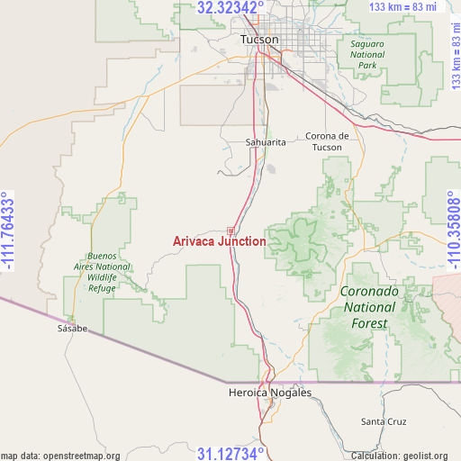
Arivaca Junction GPS coordinates[2]
31° 43' 38.316" North, 111° 3' 40.32" West
| Map corner | latitude | longitude |
|---|---|---|
| Upper-left | 32.32342°, | -111.76433° |
| Center: | 31.72731°, | -111.0612° |
| Lower-right: | 31.12734°, | -110.35808° |
| Map W x H: | 133×133 km | = 82.6×82.6mi |
| max Lat: | 71.29058° ⇑89.1% North |
| Arivaca Junction: | 31.72731° |
| min Lat: | ⇓10.9% South 19.06759° |
| min Long | Arivaca Junctio | max Long |
| -171.73463° | -111.0612° | -66.98998° |
| W 13.7%⇐ | ⇒86.3% E |
Elevation
Elevation of Arivaca Junction is 937 m = 3074 ft, and this is 642.2 m = 2107 ft above average elevation for this country.
| Max E: |
3189 m = 10463 ft | 7% |
| Arivaca Junction | 937 m 3074 ft | |
| Avg. | 294.8 m = 967 ft | |
Min E: |
-60 m = -197 ft | 93% |
See also: United States elevation on elevation.city.
Geographical zone
Arivaca Junction is located in North temperate zone (between Tropic of Cancer and the Arctic Circle). Distance of this Northern Tropic circle is 921.8 km =572.8 mi to South.| Distance of | km | miles | from Arivaca Junction |
|---|---|---|---|
| North Pole | 6479.3 | 4026 | to North |
| Arctic Circle | 3873.4 | 2406.8 | to North |
| Tropic Cancer | 921.8 | 572.8 | to South |
| Equator | 3527.7 | 2192 | to South |


Nearby cities:
15 places around Arivaca Junction: (largest is in red/bold)
• Arivaca
30.8 km =19.1 mi,  236°
236°
• Corona de Tucson
37.8 km =23.5 mi,  45°
45°
• Drexel Heights
46.1 km =28.6 mi,  3°
3°
• East Sahuarita
27.1 km =16.8 mi,  27°
27°
• Green Valley
15.5 km =9.6 mi,  24°
24°
• Littletown
48.2 km =30 mi, 21°
• Nogales
44.7 km =27.8 mi,  164°
164°
• Patagonia
35.6 km =22.1 mi,  125°
125°
• Rio Rico
29.6 km =18.4 mi, 164°
• Sahuarita
27.5 km =17.1 mi, 21°
• Sonoita
38.6 km =24 mi,  97°
97°
• Summit
39.2 km =24.4 mi, 15°
• Three Points
45.6 km =28.3 mi,  328°
328°
• Tubac
12.8 km =8 mi,  173°
173°
• Valencia West
45.3 km =28.1 mi,  353°
353°
Sources, notices
• [Note1] Compared only with cities in United States existing in our database
• [Src1] Map data: © OpenStreetMap contributors (CC-BY-SA)
• [Src2] Other city data from geonames.org with taken over terms of usage.
• [Src3] Geographical zone / Annual Mean Temperature by Robert A. Rohde @ Wikipedia
