Tucson geodata
Tucson (Arizona) is a seat of a second-order administrative division; located in United States in America/Phoenix (GMT-7) time zone. With population of 531,641 people, there are 36 cities with bigger population in this country. Compared to other cities in United States, 88% of cities are located further ↑North; 86.2% of cities are located further →East and 91.6% of cities have lower elevation than Tucson. Note1


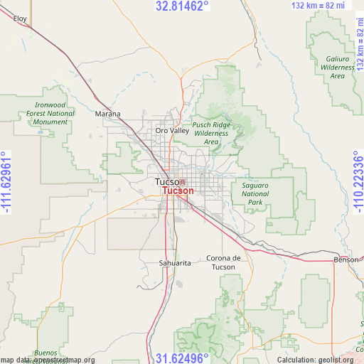
Tucson GPS coordinates[2]
32° 13' 18.264" North, 110° 55' 35.328" West
| Map corner | latitude | longitude |
|---|---|---|
| Upper-left | 32.81462°, | -111.62961° |
| Center: | 32.22174°, | -110.92648° |
| Lower-right: | 31.62496°, | -110.22336° |
| Map W x H: | 132.3×132.3 km | = 82.2×82.2mi |
| max Lat: | 71.29058° ⇑88% North |
| Tucson: | 32.22174° |
| min Lat: | ⇓12% South 19.06759° |
| min Long | Tucson | max Long |
| -171.73463° | -110.92648° | -66.98998° |
| W 13.8%⇐ | ⇒86.2% E |
Elevation
Elevation of Tucson is 757 m = 2484 ft, and this is 462.2 m = 1516 ft above average elevation for this country.
| Max E: |
3189 m = 10463 ft | 8.4% |
| Tucson | 757 m 2484 ft | |
| Avg. | 294.8 m = 967 ft | |
Min E: |
-60 m = -197 ft | 91.6% |
See also: Tucson elevation on elevation.city.
Geographical zone
Tucson is located in North temperate zone (between Tropic of Cancer and the Arctic Circle). Distance of this Northern Tropic circle is 976.8 km =607 mi to South.| Distance of | km | miles | from Tucson |
|---|---|---|---|
| North Pole | 6424.3 | 3991.9 | to North |
| Arctic Circle | 3818.5 | 2372.7 | to North |
| Tropic Cancer | 976.8 | 607 | to South |
| Equator | 3582.7 | 2226.2 | to South |


Nearby cities:
15 places around Tucson: (largest is in red/bold)
• Casas Adobes
13 km =8.1 mi,  330°
330°
• Catalina Foothills
8.5 km =5.3 mi,  4°
4°
• Drexel Heights
13.1 km =8.1 mi,  226°
226°
• East Sahuarita
31 km =19.3 mi,  180°
180°
• Flowing Wells
11.2 km =7 mi,  315°
315°
• Littletown
11.3 km =7 mi,  153°
153°
• Oro Valley
19.2 km =11.9 mi,  348°
348°
• Sahuarita
29.5 km =18.3 mi,  185°
185°
• South Tucson
4.7 km =2.9 mi,  237°
237°
• Summit
17.4 km =10.8 mi, 187°
• Tanque Verde
18.1 km =11.2 mi,  79°
79°
• Tortolita
22.6 km =14 mi,  337°
337°
• Tucson Estates
15.9 km =9.9 mi,  256°
256°
• Vail
28 km =17.4 mi,  133°
133°
• Valencia West
20.3 km =12.6 mi, 240°
Sources, notices
• [Note1] Compared only with cities in United States existing in our database
• [Src1] Map data: © OpenStreetMap contributors (CC-BY-SA)
• [Src2] Other city data from geonames.org with taken over terms of usage.
• [Src3] Geographical zone / Annual Mean Temperature by Robert A. Rohde @ Wikipedia
