Valencia West geodata
Valencia West (Arizona) is a populated place; located in United States in America/Phoenix (GMT-7) time zone. With population of 9,355 people, there are 4666 cities with bigger population in this country. Compared to other cities in United States, 88.3% of cities are located further ↑North; 86.4% of cities are located further →East and 91.6% of cities have lower elevation than Valencia West. Note1


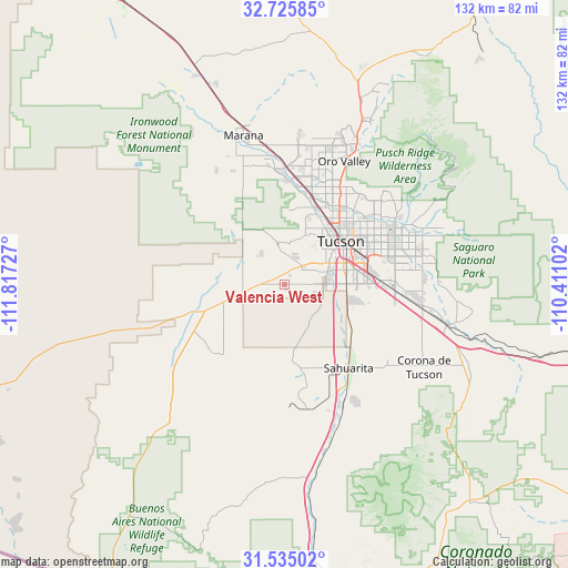
Valencia West GPS coordinates[2]
32° 7' 56.568" North, 111° 6' 50.904" West
| Map corner | latitude | longitude |
|---|---|---|
| Upper-left | 32.72585°, | -111.81727° |
| Center: | 32.13238°, | -111.11414° |
| Lower-right: | 31.53502°, | -110.41102° |
| Map W x H: | 132.4×132.4 km | = 82.3×82.3mi |
| max Lat: | 71.29058° ⇑88.3% North |
| Valencia West: | 32.13238° |
| min Lat: | ⇓11.7% South 19.06759° |
| min Long | Valencia West | max Long |
| -171.73463° | -111.11414° | -66.98998° |
| W 13.6%⇐ | ⇒86.4% E |
Elevation
Elevation of Valencia West is 757 m = 2484 ft, and this is 462.2 m = 1516 ft above average elevation for this country.
| Max E: |
3189 m = 10463 ft | 8.4% |
| Valencia West | 757 m 2484 ft | |
| Avg. | 294.8 m = 967 ft | |
Min E: |
-60 m = -197 ft | 91.6% |
See also: United States elevation on elevation.city.
Geographical zone
Valencia West is located in North temperate zone (between Tropic of Cancer and the Arctic Circle). Distance of this Northern Tropic circle is 966.9 km =600.8 mi to South.| Distance of | km | miles | from Valencia West |
|---|---|---|---|
| North Pole | 6434.3 | 3998.1 | to North |
| Arctic Circle | 3828.4 | 2378.9 | to North |
| Tropic Cancer | 966.9 | 600.8 | to South |
| Equator | 3572.8 | 2220 | to South |


Nearby cities:
15 places around Valencia West: (largest is in red/bold)
• Casas Adobes
24 km =14.9 mi,  27°
27°
• Catalina Foothills
26 km =16.2 mi,  44°
44°
• Drexel Heights
8.1 km =5 mi,  83°
83°
• East Sahuarita
27.4 km =17 mi,  140°
140°
• Flowing Wells
20.5 km =12.7 mi, 28°
• Littletown
22.7 km =14.1 mi,  90°
90°
• Oro Valley
31.9 km =19.8 mi, 25°
• Picture Rocks
26.8 km =16.7 mi,  332°
332°
• Sahuarita
24.5 km =15.2 mi, 142°
• South Tucson
15.6 km =9.7 mi,  61°
61°
• Summit
17 km =10.6 mi,  115°
115°
• Three Points
19.8 km =12.3 mi,  251°
251°
• Tortolita
32.2 km =20 mi,  16°
16°
• Tucson
20.3 km =12.6 mi, 60°
• Tucson Estates
6.5 km =4 mi, 19°
Sources, notices
• [Note1] Compared only with cities in United States existing in our database
• [Src1] Map data: © OpenStreetMap contributors (CC-BY-SA)
• [Src2] Other city data from geonames.org with taken over terms of usage.
• [Src3] Geographical zone / Annual Mean Temperature by Robert A. Rohde @ Wikipedia
