Azusa geodata
Azusa (California) is a populated place; located in United States in America/Los_Angeles (GMT-7) time zone. With population of 49,690 people, there are 960 cities with bigger population in this country. Compared to other cities in United States, 79.4% of cities are located further ↑North; 90.7% of cities are located further →East and 53.1% of cities have higher elevation than Azusa. Note1


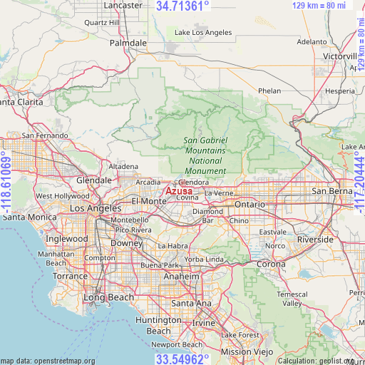
Azusa GPS coordinates[2]
34° 8' 1.032" North, 117° 54' 27.216" West
| Map corner | latitude | longitude |
|---|---|---|
| Upper-left | 34.71361°, | -118.61069° |
| Center: | 34.13362°, | -117.90756° |
| Lower-right: | 33.54962°, | -117.20444° |
| Map W x H: | 129.4×129.4 km | = 80.4×80.4mi |
| max Lat: | 71.29058° ⇑79.4% North |
| Azusa: | 34.13362° |
| min Lat: | ⇓20.6% South 19.06759° |
| min Long | Azusa | max Long |
| -171.73463° | -117.90756° | -66.98998° |
| W 9.3%⇐ | ⇒90.7% E |
Elevation
Elevation of Azusa is 187 m = 614 ft, and this is 107.8 m = 354 ft below average elevation for this country.
| Max E: |
3189 m = 10463 ft | 53.1% |
| Avg. | 294.8 m = 967 ft | |
| Azusa | 187 m = 614 ft | |
Min E: |
-60 m = -197 ft | 46.9% |
See also: Azusa elevation on elevation.city.
Geographical zone
Azusa is located in North temperate zone (between Tropic of Cancer and the Arctic Circle). Distance of this Northern Tropic circle is 1189.4 km =739.1 mi to South.| Distance of | km | miles | from Azusa |
|---|---|---|---|
| North Pole | 6211.8 | 3859.8 | to North |
| Arctic Circle | 3605.9 | 2240.6 | to North |
| Tropic Cancer | 1189.4 | 739.1 | to South |
| Equator | 3795.3 | 2358.3 | to South |


Nearby cities:
15 places around Azusa: (largest is in red/bold)
• Baldwin Park
7.3 km =4.5 mi,  222°
222°
• Bradbury
6 km =3.7 mi,  284°
284°
• Charter Oak
6.6 km =4.1 mi,  120°
120°
• Citrus
2.5 km =1.6 mi,  144°
144°
• Covina
5.1 km =3.2 mi,  161°
161°
• Duarte
6.5 km =4 mi, 275°
• Glendora
3.9 km =2.4 mi,  85°
85°
• Irwindale
3.9 km =2.4 mi, 220°
• Mayflower Village
9.6 km =6 mi,  257°
257°
• Monrovia
8.6 km =5.3 mi, 280°
• San Dimas
9.8 km =6.1 mi,  107°
107°
• Valinda
10.4 km =6.5 mi,  198°
198°
• Vincent
4.2 km =2.6 mi, 200°
• West Covina
7.8 km =4.8 mi, 201°
• West Puente Valley
10.7 km =6.6 mi,  211°
211°
Sources, notices
• [Note1] Compared only with cities in United States existing in our database
• [Src1] Map data: © OpenStreetMap contributors (CC-BY-SA)
• [Src2] Other city data from geonames.org with taken over terms of usage.
• [Src3] Geographical zone / Annual Mean Temperature by Robert A. Rohde @ Wikipedia
