Glendora geodata
Glendora (California) is a populated place; located in United States in America/Los_Angeles (GMT-7) time zone. With population of 52,009 people, there are 906 cities with bigger population in this country. Compared to other cities in United States, 79.4% of cities are located further ↑North; 90.7% of cities are located further →East and 59.9% of cities have lower elevation than Glendora. Note1


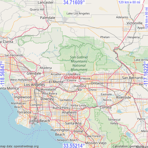
Glendora GPS coordinates[2]
34° 8' 10.032" North, 117° 51' 55.224" West
| Map corner | latitude | longitude |
|---|---|---|
| Upper-left | 34.71609°, | -118.56847° |
| Center: | 34.13612°, | -117.86534° |
| Lower-right: | 33.55214°, | -117.16222° |
| Map W x H: | 129.4×129.4 km | = 80.4×80.4mi |
| max Lat: | 71.29058° ⇑79.4% North |
| Glendora: | 34.13612° |
| min Lat: | ⇓20.6% South 19.06759° |
| min Long | Glendora | max Long |
| -171.73463° | -117.86534° | -66.98998° |
| W 9.3%⇐ | ⇒90.7% E |
Elevation
Elevation of Glendora is 239 m = 784 ft, and this is 55.8 m = 183 ft below average elevation for this country.
| Max E: |
3189 m = 10463 ft | 40.1% |
| Avg. | 294.8 m = 967 ft | |
| Glendora | 239 m = 784 ft | |
Min E: |
-60 m = -197 ft | 59.9% |
See also: Glendora elevation on elevation.city.
Geographical zone
Glendora is located in North temperate zone (between Tropic of Cancer and the Arctic Circle). Distance of this Northern Tropic circle is 1189.7 km =739.2 mi to South.| Distance of | km | miles | from Glendora |
|---|---|---|---|
| North Pole | 6211.5 | 3859.6 | to North |
| Arctic Circle | 3605.6 | 2240.4 | to North |
| Tropic Cancer | 1189.7 | 739.2 | to South |
| Equator | 3795.6 | 2358.5 | to South |


Nearby cities:
15 places around Glendora: (largest is in red/bold)
• Azusa
3.9 km =2.4 mi,  265°
265°
• Baldwin Park
10.5 km =6.5 mi,  237°
237°
• Bradbury
9.8 km =6.1 mi,  277°
277°
• Charter Oak
4.1 km =2.5 mi,  154°
154°
• Citrus
3.4 km =2.1 mi,  225°
225°
• Covina
5.6 km =3.5 mi,  204°
204°
• Duarte
10.3 km =6.4 mi, 272°
• Irwindale
7.2 km =4.5 mi, 243°
• La Verne
9.8 km =6.1 mi,  113°
113°
• Monrovia
12.4 km =7.7 mi, 276°
• San Dimas
6.3 km =3.9 mi,  121°
121°
• Valinda
12.4 km =7.7 mi,  215°
215°
• Vincent
6.8 km =4.2 mi, 232°
• Walnut
12.9 km =8 mi,  180°
180°
• West Covina
10.1 km =6.3 mi, 222°
Sources, notices
• [Note1] Compared only with cities in United States existing in our database
• [Src1] Map data: © OpenStreetMap contributors (CC-BY-SA)
• [Src2] Other city data from geonames.org with taken over terms of usage.
• [Src3] Geographical zone / Annual Mean Temperature by Robert A. Rohde @ Wikipedia
