Chatsworth geodata
Chatsworth (California) is a section of populated place; located in United States in America/Los_Angeles (GMT-7) time zone. With population of 41,255 people, there are 1162 cities with bigger population in this country. Compared to other cities in United States, 78.6% of cities are located further ↑North; 91.6% of cities are located further →East and 72.9% of cities have lower elevation than Chatsworth. Note1


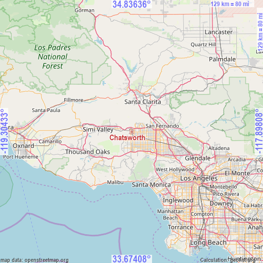
Chatsworth GPS coordinates[2]
34° 15' 26.028" North, 118° 36' 4.32" West
| Map corner | latitude | longitude |
|---|---|---|
| Upper-left | 34.83636°, | -119.30433° |
| Center: | 34.25723°, | -118.6012° |
| Lower-right: | 33.67408°, | -117.89808° |
| Map W x H: | 129.2×129.2 km | = 80.3×80.3mi |
| max Lat: | 71.29058° ⇑78.6% North |
| Chatsworth: | 34.25723° |
| min Lat: | ⇓21.4% South 19.06759° |
| min Long | Chatsworth | max Long |
| -171.73463° | -118.6012° | -66.98998° |
| W 8.4%⇐ | ⇒91.6% E |
Elevation
Elevation of Chatsworth is 301 m = 988 ft, and this is 6.2 m = 20 ft above average elevation for this country.
| Max E: |
3189 m = 10463 ft | 27.1% |
| Chatsworth | 301 m 988 ft | |
| Avg. | 294.8 m = 967 ft | |
Min E: |
-60 m = -197 ft | 72.9% |
See also: Chatsworth elevation on elevation.city.
Geographical zone
Chatsworth is located in North temperate zone (between Tropic of Cancer and the Arctic Circle). Distance of this Northern Tropic circle is 1203.1 km =747.6 mi to South.| Distance of | km | miles | from Chatsworth |
|---|---|---|---|
| North Pole | 6198 | 3851.3 | to North |
| Arctic Circle | 3592.1 | 2232 | to North |
| Tropic Cancer | 1203.1 | 747.6 | to South |
| Equator | 3809 | 2366.8 | to South |


Nearby cities:
15 places around Chatsworth: (largest is in red/bold)
• Calabasas
11.6 km =7.2 mi,  197°
197°
• Canoga Park
6.2 km =3.9 mi,  177°
177°
• Encino
14.3 km =8.9 mi,  139°
139°
• Hidden Hills
11.8 km =7.3 mi, 203°
• North Hills
11 km =6.8 mi,  102°
102°
• Northridge
6.7 km =4.2 mi,  118°
118°
• San Fernando
15.2 km =9.4 mi,  79°
79°
• Santa Clarita
15.9 km =9.9 mi,  19°
19°
• Santa Susana
10 km =6.2 mi,  279°
279°
• Simi Valley
16.6 km =10.3 mi,  274°
274°
• Stevenson Ranch
15 km =9.3 mi,  9°
9°
• Valley Glen
15.8 km =9.8 mi, 118°
• Van Nuys
16 km =9.9 mi, 119°
• West Hills
7.7 km =4.8 mi,  210°
210°
• Woodland Hills
9.9 km =6.2 mi, 182°
Sources, notices
• [Note1] Compared only with cities in United States existing in our database
• [Src1] Map data: © OpenStreetMap contributors (CC-BY-SA)
• [Src2] Other city data from geonames.org with taken over terms of usage.
• [Src3] Geographical zone / Annual Mean Temperature by Robert A. Rohde @ Wikipedia
