Stevenson Ranch geodata
Stevenson Ranch (California) is a populated place; located in United States in America/Los_Angeles (GMT-7) time zone. With population of 17,557 people, there are 2841 cities with bigger population in this country. Compared to other cities in United States, 78.1% of cities are located further ↑North; 91.6% of cities are located further →East and 85.2% of cities have lower elevation than Stevenson Ranch. Note1


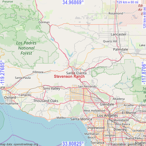
Stevenson Ranch GPS coordinates[2]
34° 23' 25.728" North, 118° 34' 25.392" West
| Map corner | latitude | longitude |
|---|---|---|
| Upper-left | 34.96869°, | -119.27685° |
| Center: | 34.39048°, | -118.57372° |
| Lower-right: | 33.80825°, | -117.8706° |
| Map W x H: | 129×129 km | = 80.2×80.2mi |
| max Lat: | 71.29058° ⇑78.1% North |
| Stevenson Ranch: | 34.39048° |
| min Lat: | ⇓21.9% South 19.06759° |
| min Long | Stevenson Ranch | max Long |
| -171.73463° | -118.57372° | -66.98998° |
| W 8.4%⇐ | ⇒91.6% E |
Elevation
Elevation of Stevenson Ranch is 428 m = 1404 ft, and this is 133.2 m = 437 ft above average elevation for this country.
| Max E: |
3189 m = 10463 ft | 14.8% |
| Stevenson Ranch | 428 m 1404 ft | |
| Avg. | 294.8 m = 967 ft | |
Min E: |
-60 m = -197 ft | 85.2% |
See also: United States elevation on elevation.city.
Geographical zone
Stevenson Ranch is located in North temperate zone (between Tropic of Cancer and the Arctic Circle). Distance of this Northern Tropic circle is 1217.9 km =756.8 mi to South.| Distance of | km | miles | from Stevenson Ranch |
|---|---|---|---|
| North Pole | 6183.2 | 3842.1 | to North |
| Arctic Circle | 3577.3 | 2222.8 | to North |
| Tropic Cancer | 1217.9 | 756.8 | to South |
| Equator | 3823.9 | 2376.1 | to South |


Nearby cities:
15 places around Stevenson Ranch: (largest is in red/bold)
• Canoga Park
21.2 km =13.2 mi,  186°
186°
• Castaic
11.8 km =7.3 mi,  337°
337°
• Chatsworth
15 km =9.3 mi, 189°
• North Hills
19 km =11.8 mi,  154°
154°
• Northridge
18.3 km =11.4 mi,  169°
169°
• Piru
20.4 km =12.7 mi,  277°
277°
• San Fernando
17.3 km =10.7 mi,  134°
134°
• Santa Clarita
2.9 km =1.8 mi,  87°
87°
• Santa Susana
18.1 km =11.2 mi,  223°
223°
• Shadow Hills
24.9 km =15.5 mi, 125°
• Simi Valley
23.3 km =14.5 mi,  234°
234°
• Val Verde
9.8 km =6.1 mi,  308°
308°
• Valencia
6.8 km =4.2 mi,  330°
330°
• West Hills
22.4 km =13.9 mi,  196°
196°
• Woodland Hills
24.9 km =15.5 mi, 186°
Sources, notices
• [Note1] Compared only with cities in United States existing in our database
• [Src1] Map data: © OpenStreetMap contributors (CC-BY-SA)
• [Src2] Other city data from geonames.org with taken over terms of usage.
• [Src3] Geographical zone / Annual Mean Temperature by Robert A. Rohde @ Wikipedia
