Coachella geodata
Coachella (California) is a populated place; located in United States in America/Los_Angeles (GMT-7) time zone. With population of 44,635 people, there are 1067 cities with bigger population in this country. Compared to other cities in United States, 82.2% of cities are located further ↑North; 89.2% of cities are located further →East and 100% of cities have higher elevation than Coachella. Note1


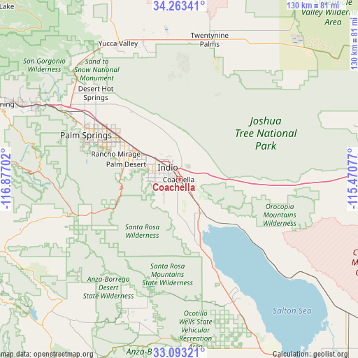
Coachella GPS coordinates[2]
33° 40' 49.08" North, 116° 10' 26.004" West
| Map corner | latitude | longitude |
|---|---|---|
| Upper-left | 34.26341°, | -116.87702° |
| Center: | 33.6803°, | -116.17389° |
| Lower-right: | 33.09321°, | -115.47077° |
| Map W x H: | 130.1×130.1 km | = 80.8×80.8mi |
| max Lat: | 71.29058° ⇑82.2% North |
| Coachella: | 33.6803° |
| min Lat: | ⇓17.8% South 19.06759° |
| min Long | Coachella | max Long |
| -171.73463° | -116.17389° | -66.98998° |
| W 10.8%⇐ | ⇒89.2% E |
Elevation
Elevation of Coachella is -21 m = -69 ft, and this is 315.8 m = 1036 ft below average elevation for this country.
| Max E: |
3189 m = 10463 ft | 100% |
| Avg. | 294.8 m = 967 ft | |
| Coachella | -21 m = -69 ft | |
Min E: |
-60 m = -197 ft | 0% |
See also: Coachella elevation on elevation.city.
Geographical zone
Coachella is located in North temperate zone (between Tropic of Cancer and the Arctic Circle). Distance of this Northern Tropic circle is 1139 km =707.7 mi to South.| Distance of | km | miles | from Coachella |
|---|---|---|---|
| North Pole | 6262.2 | 3891.1 | to North |
| Arctic Circle | 3656.3 | 2271.9 | to North |
| Tropic Cancer | 1139 | 707.7 | to South |
| Equator | 3744.9 | 2327 | to South |


Nearby cities:
15 places around Coachella: (largest is in red/bold)
• Bermuda Dunes
12.7 km =7.9 mi,  303°
303°
• Cathedral City
29.1 km =18.1 mi,  292°
292°
• Desert Shores
33.1 km =20.6 mi,  157°
157°
• Indian Wells
16.2 km =10.1 mi,  284°
284°
• Indio
6 km =3.7 mi,  318°
318°
• Indio Hills
17.6 km =10.9 mi,  342°
342°
• La Quinta
12.7 km =7.9 mi,  261°
261°
• Mecca
14.9 km =9.3 mi,  143°
143°
• Oasis
24.8 km =15.4 mi, 163°
• Palm Desert
19.4 km =12.1 mi, 284°
• Rancho Mirage
23.1 km =14.4 mi, 286°
• Sky Valley
28.6 km =17.8 mi, 324°
• Thermal
5.5 km =3.4 mi, 144°
• Thousand Palms
25.3 km =15.7 mi,  307°
307°
• Vista Santa Rosa
7.1 km =4.4 mi,  215°
215°
Sources, notices
• [Note1] Compared only with cities in United States existing in our database
• [Src1] Map data: © OpenStreetMap contributors (CC-BY-SA)
• [Src2] Other city data from geonames.org with taken over terms of usage.
• [Src3] Geographical zone / Annual Mean Temperature by Robert A. Rohde @ Wikipedia
