Thousand Palms geodata
Thousand Palms (California) is a populated place; located in United States in America/Los_Angeles (GMT-7) time zone. With population of 7,715 people, there are 5414 cities with bigger population in this country. Compared to other cities in United States, 81.4% of cities are located further ↑North; 89.3% of cities are located further →East and 74.4% of cities have higher elevation than Thousand Palms. Note1


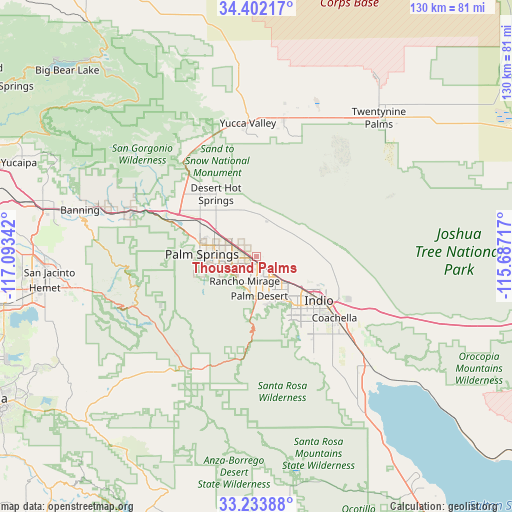
Thousand Palms GPS coordinates[2]
33° 49' 12.072" North, 116° 23' 25.044" West
| Map corner | latitude | longitude |
|---|---|---|
| Upper-left | 34.40217°, | -117.09342° |
| Center: | 33.82002°, | -116.39029° |
| Lower-right: | 33.23388°, | -115.68717° |
| Map W x H: | 129.9×129.9 km | = 80.7×80.7mi |
| max Lat: | 71.29058° ⇑81.4% North |
| Thousand Palms: | 33.82002° |
| min Lat: | ⇓18.6% South 19.06759° |
| min Long | Thousand Palms | max Long |
| -171.73463° | -116.39029° | -66.98998° |
| W 10.7%⇐ | ⇒89.3% E |
Elevation
Elevation of Thousand Palms is 75 m = 246 ft, and this is 219.8 m = 721 ft below average elevation for this country.
| Max E: |
3189 m = 10463 ft | 74.4% |
| Avg. | 294.8 m = 967 ft | |
| Thousand Palms | 75 m = 246 ft | |
Min E: |
-60 m = -197 ft | 25.6% |
See also: United States elevation on elevation.city.
Geographical zone
Thousand Palms is located in North temperate zone (between Tropic of Cancer and the Arctic Circle). Distance of this Northern Tropic circle is 1154.5 km =717.4 mi to South.| Distance of | km | miles | from Thousand Palms |
|---|---|---|---|
| North Pole | 6246.6 | 3881.5 | to North |
| Arctic Circle | 3640.7 | 2262.2 | to North |
| Tropic Cancer | 1154.5 | 717.4 | to South |
| Equator | 3760.4 | 2336.6 | to South |


Nearby cities:
15 places around Thousand Palms: (largest is in red/bold)
• Bermuda Dunes
12.7 km =7.9 mi,  132°
132°
• Cathedral City
8.3 km =5.2 mi,  237°
237°
• Coachella
25.3 km =15.7 mi, 127°
• Desert Edge
12.5 km =7.8 mi,  337°
337°
• Desert Hot Springs
18.9 km =11.7 mi,  326°
326°
• Garnet
17 km =10.6 mi,  302°
302°
• Indian Wells
12.2 km =7.6 mi,  158°
158°
• Indio
19.5 km =12.1 mi,  124°
124°
• Indio Hills
14.7 km =9.1 mi,  85°
85°
• La Quinta
18.9 km =11.7 mi, 156°
• Palm Desert
10.9 km =6.8 mi,  173°
173°
• Palm Springs
14.4 km =8.9 mi,  274°
274°
• Rancho Mirage
9.2 km =5.7 mi,  193°
193°
• Sky Valley
8.5 km =5.3 mi,  24°
24°
• Vista Santa Rosa
26.7 km =16.6 mi,  143°
143°
Sources, notices
• [Note1] Compared only with cities in United States existing in our database
• [Src1] Map data: © OpenStreetMap contributors (CC-BY-SA)
• [Src2] Other city data from geonames.org with taken over terms of usage.
• [Src3] Geographical zone / Annual Mean Temperature by Robert A. Rohde @ Wikipedia
