Colfax geodata
Colfax (California) is a populated place; located in United States in America/Los_Angeles (GMT-7) time zone. With population of 2,005 people, there are 11929 cities with bigger population in this country. Compared to other cities in United States, 53.9% of cities are located further ↑North; 93.7% of cities are located further →East and 91.4% of cities have lower elevation than Colfax. Note1


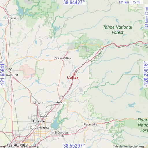
Colfax GPS coordinates[2]
39° 6' 2.628" North, 120° 57' 11.808" West
| Map corner | latitude | longitude |
|---|---|---|
| Upper-left | 39.64427°, | -121.65641° |
| Center: | 39.10073°, | -120.95328° |
| Lower-right: | 38.55297°, | -120.25016° |
| Map W x H: | 121.3×121.3 km | = 75.4×75.4mi |
| max Lat: | 71.29058° ⇑53.9% North |
| Colfax: | 39.10073° |
| min Lat: | ⇓46.1% South 19.06759° |
| min Long | Colfax | max Long |
| -171.73463° | -120.95328° | -66.98998° |
| W 6.3%⇐ | ⇒93.7% E |
Elevation
Elevation of Colfax is 739 m = 2425 ft, and this is 444.2 m = 1457 ft above average elevation for this country.
| Max E: |
3189 m = 10463 ft | 8.6% |
| Colfax | 739 m 2425 ft | |
| Avg. | 294.8 m = 967 ft | |
Min E: |
-60 m = -197 ft | 91.4% |
See also: United States elevation on elevation.city.
Geographical zone
Colfax is located in North temperate zone (between Tropic of Cancer and the Arctic Circle). Distance of this Northern Tropic circle is 1741.7 km =1082.2 mi to South.| Distance of | km | miles | from Colfax |
|---|---|---|---|
| North Pole | 5659.5 | 3516.6 | to North |
| Arctic Circle | 3053.6 | 1897.4 | to North |
| Tropic Cancer | 1741.7 | 1082.2 | to South |
| Equator | 4347.6 | 2701.5 | to South |


Nearby cities:
15 places around Colfax: (largest is in red/bold)
• Alta
17 km =10.6 mi,  46°
46°
• Alta Sierra
9.8 km =6.1 mi,  297°
297°
• Auburn
25.1 km =15.6 mi,  205°
205°
• Auburn Lake Trails
20.7 km =12.9 mi,  179°
179°
• Cool
24.3 km =15.1 mi,  192°
192°
• Foresthill
14.7 km =9.1 mi,  127°
127°
• Georgetown
23.7 km =14.7 mi,  155°
155°
• Grass Valley
16.1 km =10 mi,  324°
324°
• Lake Wildwood
25.9 km =16.1 mi, 304°
• Lake of the Pines
11.2 km =7 mi,  232°
232°
• Meadow Vista
12.6 km =7.8 mi, 208°
• Nevada City
18.7 km =11.6 mi,  342°
342°
• North Auburn
21.9 km =13.6 mi, 210°
• Penn Valley
23.1 km =14.4 mi, 297°
• Rough and Ready
21.3 km =13.2 mi,  312°
312°
Sources, notices
• [Note1] Compared only with cities in United States existing in our database
• [Src1] Map data: © OpenStreetMap contributors (CC-BY-SA)
• [Src2] Other city data from geonames.org with taken over terms of usage.
• [Src3] Geographical zone / Annual Mean Temperature by Robert A. Rohde @ Wikipedia
