Auburn Lake Trails geodata
Auburn Lake Trails (California) is a populated place; located in United States in America/Los_Angeles (GMT-7) time zone. With population of 3,426 people, there are 8949 cities with bigger population in this country. Compared to other cities in United States, 55.7% of cities are located further ↑North; 93.7% of cities are located further →East and 89.4% of cities have lower elevation than Auburn Lake Trails. Note1


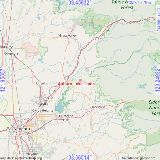
Auburn Lake Trails GPS coordinates[2]
38° 54' 51.624" North, 120° 57' 8.784" West
| Map corner | latitude | longitude |
|---|---|---|
| Upper-left | 39.45932°, | -121.65557° |
| Center: | 38.91434°, | -120.95244° |
| Lower-right: | 38.36514°, | -120.24932° |
| Map W x H: | 121.7×121.7 km | = 75.6×75.6mi |
| max Lat: | 71.29058° ⇑55.7% North |
| Auburn Lake Trails: | 38.91434° |
| min Lat: | ⇓44.3% South 19.06759° |
| min Long | Auburn Lake Tra | max Long |
| -171.73463° | -120.95244° | -66.98998° |
| W 6.3%⇐ | ⇒93.7% E |
Elevation
Elevation of Auburn Lake Trails is 585 m = 1919 ft, and this is 290.2 m = 952 ft above average elevation for this country.
| Max E: |
3189 m = 10463 ft | 10.6% |
| Auburn Lake Trails | 585 m 1919 ft | |
| Avg. | 294.8 m = 967 ft | |
Min E: |
-60 m = -197 ft | 89.4% |
See also: United States elevation on elevation.city.
Geographical zone
Auburn Lake Trails is located in North temperate zone (between Tropic of Cancer and the Arctic Circle). Distance of this Northern Tropic circle is 1721 km =1069.4 mi to South.| Distance of | km | miles | from Auburn Lake Trails |
|---|---|---|---|
| North Pole | 5680.2 | 3529.5 | to North |
| Arctic Circle | 3074.3 | 1910.3 | to North |
| Tropic Cancer | 1721 | 1069.4 | to South |
| Equator | 4326.9 | 2688.6 | to South |


Nearby cities:
15 places around Auburn Lake Trails: (largest is in red/bold)
• Alta Sierra
26.7 km =16.6 mi,  340°
340°
• Auburn
10.9 km =6.8 mi,  259°
259°
• Colfax
20.7 km =12.9 mi,  359°
359°
• Coloma
13.8 km =8.6 mi,  157°
157°
• Cool
6.2 km =3.9 mi,  240°
240°
• Foresthill
16.5 km =10.3 mi,  44°
44°
• Georgetown
9.9 km =6.2 mi,  94°
94°
• Granite Bay
24.8 km =15.4 mi,  227°
227°
• Lake of the Pines
16.6 km =10.3 mi,  327°
327°
• Loomis
23.3 km =14.5 mi, 243°
• Meadow Vista
11.4 km =7.1 mi, 328°
• Newcastle
16.3 km =10.1 mi,  254°
254°
• North Auburn
11.4 km =7.1 mi,  279°
279°
• Penryn
20 km =12.4 mi, 249°
• Placerville
24.5 km =15.2 mi,  147°
147°
Sources, notices
• [Note1] Compared only with cities in United States existing in our database
• [Src1] Map data: © OpenStreetMap contributors (CC-BY-SA)
• [Src2] Other city data from geonames.org with taken over terms of usage.
• [Src3] Geographical zone / Annual Mean Temperature by Robert A. Rohde @ Wikipedia
