Concord geodata
Concord (California) is a populated place; located in United States in America/Los_Angeles (GMT-7) time zone. With population of 128,667 people, there are 241 cities with bigger population in this country. Compared to other cities in United States, 61.8% of cities are located further ↑North; 95.1% of cities are located further →East and 86.2% of cities have higher elevation than Concord. Note1


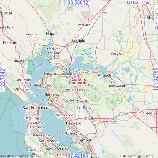
Concord GPS coordinates[2]
37° 58' 40.728" North, 122° 1' 51.852" West
| Map corner | latitude | longitude |
|---|---|---|
| Upper-left | 38.53012°, | -122.7342° |
| Center: | 37.97798°, | -122.03107° |
| Lower-right: | 37.42165°, | -121.32795° |
| Map W x H: | 123.3×123.2 km | = 76.6×76.6mi |
| max Lat: | 71.29058° ⇑61.8% North |
| Concord: | 37.97798° |
| min Lat: | ⇓38.2% South 19.06759° |
| min Long | Concord | max Long |
| -171.73463° | -122.03107° | -66.98998° |
| W 4.9%⇐ | ⇒95.1% E |
Elevation
Elevation of Concord is 25 m = 82 ft, and this is 269.8 m = 885 ft below average elevation for this country.
| Max E: |
3189 m = 10463 ft | 86.2% |
| Avg. | 294.8 m = 967 ft | |
| Concord | 25 m = 82 ft | |
Min E: |
-60 m = -197 ft | 13.8% |
See also: Concord elevation on elevation.city.
Geographical zone
Concord is located in North temperate zone (between Tropic of Cancer and the Arctic Circle). Distance of this Northern Tropic circle is 1616.8 km =1004.6 mi to South.| Distance of | km | miles | from Concord |
|---|---|---|---|
| North Pole | 5784.3 | 3594.2 | to North |
| Arctic Circle | 3178.4 | 1975 | to North |
| Tropic Cancer | 1616.8 | 1004.6 | to South |
| Equator | 4222.8 | 2623.9 | to South |


Nearby cities:
15 places around Concord: (largest is in red/bold)
• Acalanes Ridge
9.1 km =5.7 mi,  207°
207°
• Bay Point
8.3 km =5.2 mi,  46°
46°
• Clayton
9.3 km =5.8 mi,  116°
116°
• Clyde
5.3 km =3.3 mi,  1°
1°
• Contra Costa Centre
6.1 km =3.8 mi,  202°
202°
• Lafayette
12.8 km =8 mi,  216°
216°
• Martinez
10.1 km =6.3 mi,  297°
297°
• Mountain View
8.3 km =5.2 mi,  294°
294°
• North Gate
8.5 km =5.3 mi,  160°
160°
• Pacheco
3.9 km =2.4 mi,  279°
279°
• Pleasant Hill
4.2 km =2.6 mi, 218°
• Saranap
11.1 km =6.9 mi, 200°
• Vine Hill
6.6 km =4.1 mi, 300°
• Waldon
6.1 km =3.8 mi, 200°
• Walnut Creek
8.5 km =5.3 mi, 200°
Sources, notices
• [Note1] Compared only with cities in United States existing in our database
• [Src1] Map data: © OpenStreetMap contributors (CC-BY-SA)
• [Src2] Other city data from geonames.org with taken over terms of usage.
• [Src3] Geographical zone / Annual Mean Temperature by Robert A. Rohde @ Wikipedia
