Emerald Lake Hills geodata
Emerald Lake Hills (California) is a populated place; located in United States in America/Los_Angeles (GMT-7) time zone. With population of 4,278 people, there are 7888 cities with bigger population in this country. Compared to other cities in United States, 64.2% of cities are located further ↑North; 95.9% of cities are located further →East and 59.3% of cities have higher elevation than Emerald Lake Hills. Note1


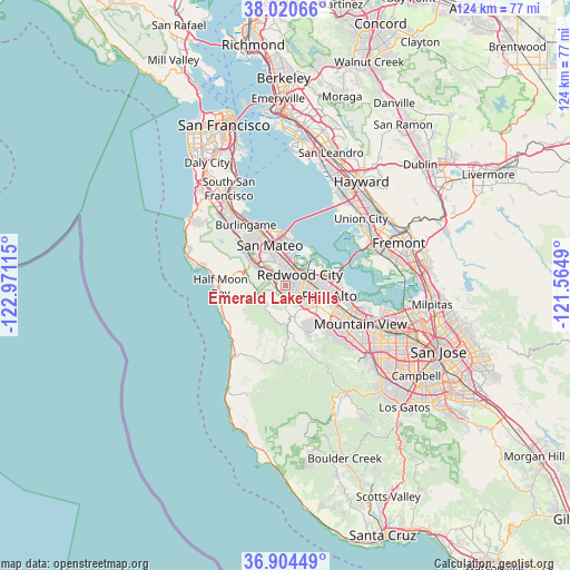
Emerald Lake Hills GPS coordinates[2]
37° 27' 52.776" North, 122° 16' 4.872" West
| Map corner | latitude | longitude |
|---|---|---|
| Upper-left | 38.02066°, | -122.97115° |
| Center: | 37.46466°, | -122.26802° |
| Lower-right: | 36.90449°, | -121.5649° |
| Map W x H: | 124.1×124.1 km | = 77.1×77.1mi |
| max Lat: | 71.29058° ⇑64.2% North |
| Emerald Lake Hills: | 37.46466° |
| min Lat: | ⇓35.8% South 19.06759° |
| min Long | Emerald Lake Hi | max Long |
| -171.73463° | -122.26802° | -66.98998° |
| W 4.1%⇐ | ⇒95.9% E |
Elevation
Elevation of Emerald Lake Hills is 158 m = 518 ft, and this is 136.8 m = 449 ft below average elevation for this country.
| Max E: |
3189 m = 10463 ft | 59.3% |
| Avg. | 294.8 m = 967 ft | |
| Emerald Lake Hills | 158 m = 518 ft | |
Min E: |
-60 m = -197 ft | 40.7% |
See also: United States elevation on elevation.city.
Geographical zone
Emerald Lake Hills is located in North temperate zone (between Tropic of Cancer and the Arctic Circle). Distance of this Northern Tropic circle is 1559.8 km =969.2 mi to South.| Distance of | km | miles | from Emerald Lake Hills |
|---|---|---|---|
| North Pole | 5841.4 | 3629.7 | to North |
| Arctic Circle | 3235.5 | 2010.4 | to North |
| Tropic Cancer | 1559.8 | 969.2 | to South |
| Equator | 4165.7 | 2588.4 | to South |


Nearby cities:
15 places around Emerald Lake Hills: (largest is in red/bold)
• Atherton
6.2 km =3.9 mi,  93°
93°
• Belmont
6.2 km =3.9 mi,  353°
353°
• East Palo Alto
11.2 km =7 mi, 87°
• Foster City
10.4 km =6.5 mi,  358°
358°
• Highlands-Baywood Park
9.4 km =5.8 mi,  313°
313°
• Ladera
9.5 km =5.9 mi,  139°
139°
• Menlo Park
7.7 km =4.8 mi,  99°
99°
• North Fair Oaks
6.4 km =4 mi,  80°
80°
• Portola Valley
9.4 km =5.8 mi,  162°
162°
• Redwood City
3.6 km =2.2 mi,  50°
50°
• Redwood Shores
7.7 km =4.8 mi,  13°
13°
• San Carlos
4.8 km =3 mi, 7°
• Stanford
10.1 km =6.3 mi,  116°
116°
• West Menlo Park
6.7 km =4.2 mi, 121°
• Woodside
4.1 km =2.5 mi, 162°
Sources, notices
• [Note1] Compared only with cities in United States existing in our database
• [Src1] Map data: © OpenStreetMap contributors (CC-BY-SA)
• [Src2] Other city data from geonames.org with taken over terms of usage.
• [Src3] Geographical zone / Annual Mean Temperature by Robert A. Rohde @ Wikipedia
