Gridley geodata
Gridley (California) is a populated place; located in United States in America/Los_Angeles (GMT-7) time zone. With population of 6,582 people, there are 6061 cities with bigger population in this country. Compared to other cities in United States, 51.8% of cities are located further ↑North; 94.5% of cities are located further →East and 85.1% of cities have higher elevation than Gridley. Note1


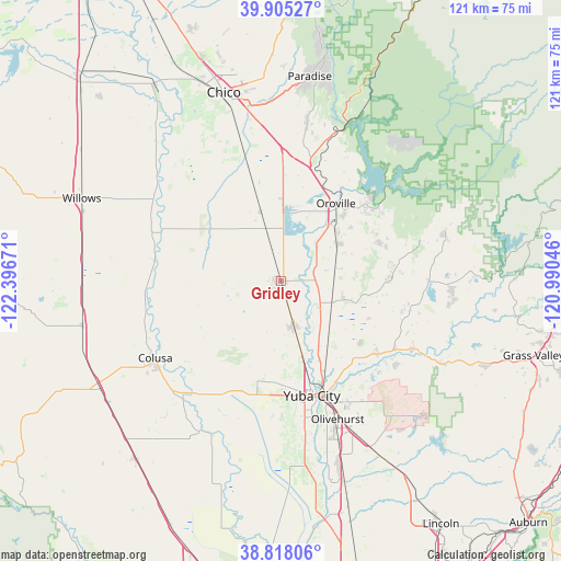
Gridley GPS coordinates[2]
39° 21' 49.608" North, 121° 41' 36.888" West
| Map corner | latitude | longitude |
|---|---|---|
| Upper-left | 39.90527°, | -122.39671° |
| Center: | 39.36378°, | -121.69358° |
| Lower-right: | 38.81806°, | -120.99046° |
| Map W x H: | 120.9×120.9 km | = 75.1×75.1mi |
| max Lat: | 71.29058° ⇑51.8% North |
| Gridley: | 39.36378° |
| min Lat: | ⇓48.2% South 19.06759° |
| min Long | Gridley | max Long |
| -171.73463° | -121.69358° | -66.98998° |
| W 5.5%⇐ | ⇒94.5% E |
Elevation
Elevation of Gridley is 28 m = 92 ft, and this is 266.8 m = 875 ft below average elevation for this country.
| Max E: |
3189 m = 10463 ft | 85.1% |
| Avg. | 294.8 m = 967 ft | |
| Gridley | 28 m = 92 ft | |
Min E: |
-60 m = -197 ft | 14.9% |
See also: United States elevation on elevation.city.
Geographical zone
Gridley is located in North temperate zone (between Tropic of Cancer and the Arctic Circle). Distance of this Northern Tropic circle is 1770.9 km =1100.4 mi to South.| Distance of | km | miles | from Gridley |
|---|---|---|---|
| North Pole | 5630.2 | 3498.4 | to North |
| Arctic Circle | 3024.3 | 1879.2 | to North |
| Tropic Cancer | 1770.9 | 1100.4 | to South |
| Equator | 4376.8 | 2719.6 | to South |


Nearby cities:
15 places around Gridley: (largest is in red/bold)
• Bangor
24.9 km =15.5 mi,  83°
83°
• Biggs
5.7 km =3.5 mi,  343°
343°
• Linda
29 km =18 mi,  154°
154°
• Live Oak
10.2 km =6.3 mi,  163°
163°
• Loma Rica
24.4 km =15.2 mi,  103°
103°
• Marysville
25.8 km =16 mi, 160°
• Oroville
20.4 km =12.7 mi,  34°
34°
• Oroville East
24.9 km =15.5 mi,  48°
48°
• Palermo
15.6 km =9.7 mi,  59°
59°
• South Oroville
19.1 km =11.9 mi,  39°
39°
• South Yuba City
27.9 km =17.3 mi,  170°
170°
• Sutter
23.2 km =14.4 mi,  192°
192°
• Thermalito
18.8 km =11.7 mi, 29°
• Tierra Buena
24 km =14.9 mi, 174°
• Yuba City
25.7 km =16 mi, 165°
Sources, notices
• [Note1] Compared only with cities in United States existing in our database
• [Src1] Map data: © OpenStreetMap contributors (CC-BY-SA)
• [Src2] Other city data from geonames.org with taken over terms of usage.
• [Src3] Geographical zone / Annual Mean Temperature by Robert A. Rohde @ Wikipedia
