Homeland geodata
Homeland (California) is a populated place; located in United States in America/Los_Angeles (GMT-7) time zone. With population of 5,969 people, there are 6429 cities with bigger population in this country. Compared to other cities in United States, 81.9% of cities are located further ↑North; 89.9% of cities are located further →East and 87.7% of cities have lower elevation than Homeland. Note1


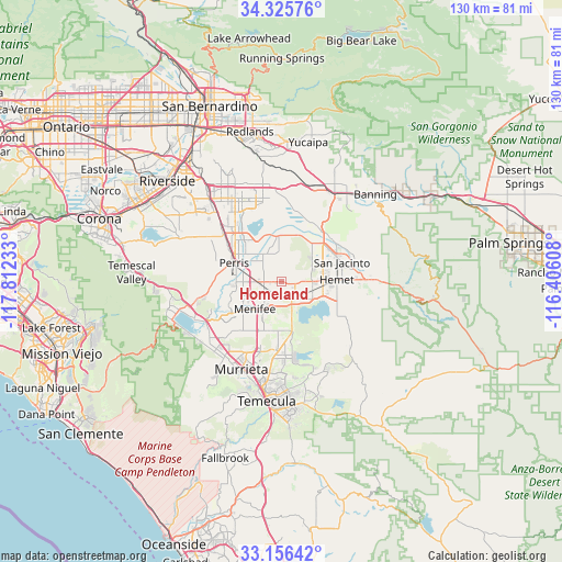
Homeland GPS coordinates[2]
33° 44' 35.088" North, 117° 6' 33.12" West
| Map corner | latitude | longitude |
|---|---|---|
| Upper-left | 34.32576°, | -117.81233° |
| Center: | 33.74308°, | -117.1092° |
| Lower-right: | 33.15642°, | -116.40608° |
| Map W x H: | 130×130 km | = 80.8×80.8mi |
| max Lat: | 71.29058° ⇑81.9% North |
| Homeland: | 33.74308° |
| min Lat: | ⇓18.1% South 19.06759° |
| min Long | Homeland | max Long |
| -171.73463° | -117.1092° | -66.98998° |
| W 10.1%⇐ | ⇒89.9% E |
Elevation
Elevation of Homeland is 492 m = 1614 ft, and this is 197.2 m = 647 ft above average elevation for this country.
| Max E: |
3189 m = 10463 ft | 12.3% |
| Homeland | 492 m 1614 ft | |
| Avg. | 294.8 m = 967 ft | |
Min E: |
-60 m = -197 ft | 87.7% |
See also: United States elevation on elevation.city.
Geographical zone
Homeland is located in North temperate zone (between Tropic of Cancer and the Arctic Circle). Distance of this Northern Tropic circle is 1146 km =712.1 mi to South.| Distance of | km | miles | from Homeland |
|---|---|---|---|
| North Pole | 6255.2 | 3886.8 | to North |
| Arctic Circle | 3649.3 | 2267.6 | to North |
| Tropic Cancer | 1146 | 712.1 | to South |
| Equator | 3751.9 | 2331.3 | to South |


Nearby cities:
15 places around Homeland: (largest is in red/bold)
• Canyon Lake
16.5 km =10.3 mi,  246°
246°
• East Hemet
15.7 km =9.8 mi,  91°
91°
• Good Hope
14.8 km =9.2 mi,  279°
279°
• Green Acres
3.1 km =1.9 mi,  100°
100°
• Hemet
12.6 km =7.8 mi, 87°
• Lakeview
10.7 km =6.6 mi,  355°
355°
• Meadowbrook
16.4 km =10.2 mi,  263°
263°
• Menifee
3.8 km =2.4 mi,  244°
244°
• Nuevo
7.3 km =4.5 mi,  332°
332°
• Perris
11.9 km =7.4 mi,  291°
291°
• Quail Valley
13.2 km =8.2 mi, 252°
• Romoland
6.1 km =3.8 mi,  272°
272°
• San Jacinto
14.6 km =9.1 mi,  71°
71°
• Sun City
9 km =5.6 mi, 245°
• Winchester
4.6 km =2.9 mi,  150°
150°
Sources, notices
• [Note1] Compared only with cities in United States existing in our database
• [Src1] Map data: © OpenStreetMap contributors (CC-BY-SA)
• [Src2] Other city data from geonames.org with taken over terms of usage.
• [Src3] Geographical zone / Annual Mean Temperature by Robert A. Rohde @ Wikipedia
