Perris geodata
Perris (California) is a populated place; located in United States in America/Los_Angeles (GMT-7) time zone. With population of 74,971 people, there are 541 cities with bigger population in this country. Compared to other cities in United States, 81.6% of cities are located further ↑North; 90% of cities are located further →East and 86.1% of cities have lower elevation than Perris. Note1


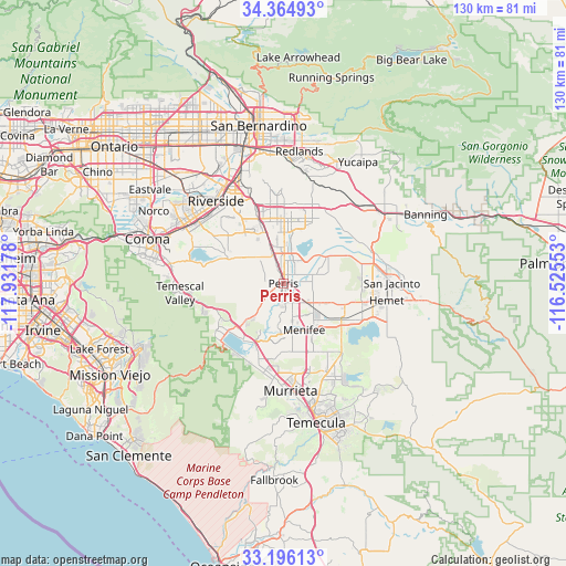
Perris GPS coordinates[2]
33° 46' 57.072" North, 117° 13' 43.14" West
| Map corner | latitude | longitude |
|---|---|---|
| Upper-left | 34.36493°, | -117.93178° |
| Center: | 33.78252°, | -117.22865° |
| Lower-right: | 33.19613°, | -116.52553° |
| Map W x H: | 130×130 km | = 80.8×80.8mi |
| max Lat: | 71.29058° ⇑81.6% North |
| Perris: | 33.78252° |
| min Lat: | ⇓18.4% South 19.06759° |
| min Long | Perris | max Long |
| -171.73463° | -117.22865° | -66.98998° |
| W 10%⇐ | ⇒90% E |
Elevation
Elevation of Perris is 445 m = 1460 ft, and this is 150.2 m = 493 ft above average elevation for this country.
| Max E: |
3189 m = 10463 ft | 13.9% |
| Perris | 445 m 1460 ft | |
| Avg. | 294.8 m = 967 ft | |
Min E: |
-60 m = -197 ft | 86.1% |
See also: Perris elevation on elevation.city.
Geographical zone
Perris is located in North temperate zone (between Tropic of Cancer and the Arctic Circle). Distance of this Northern Tropic circle is 1150.3 km =714.8 mi to South.| Distance of | km | miles | from Perris |
|---|---|---|---|
| North Pole | 6250.8 | 3884.1 | to North |
| Arctic Circle | 3644.9 | 2264.8 | to North |
| Tropic Cancer | 1150.3 | 714.8 | to South |
| Equator | 3756.3 | 2334.1 | to South |


Nearby cities:
15 places around Perris: (largest is in red/bold)
• Canyon Lake
11.6 km =7.2 mi,  200°
200°
• Good Hope
4.1 km =2.5 mi,  240°
240°
• Green Acres
14.9 km =9.3 mi,  109°
109°
• Homeland
11.9 km =7.4 mi, 111°
• Lake Elsinore
15.7 km =9.8 mi,  215°
215°
• Lakeview
12 km =7.5 mi,  58°
58°
• March Air Force Base
12.6 km =7.8 mi,  345°
345°
• Mead Valley
8.4 km =5.2 mi,  312°
312°
• Meadowbrook
8.2 km =5.1 mi, 219°
• Menifee
9.7 km =6 mi,  128°
128°
• Nuevo
7.9 km =4.9 mi,  74°
74°
• Quail Valley
8.5 km =5.3 mi,  190°
190°
• Romoland
6.4 km =4 mi, 129°
• Sun City
8.7 km =5.4 mi,  160°
160°
• Winchester
15.8 km =9.8 mi,  122°
122°
Sources, notices
• [Note1] Compared only with cities in United States existing in our database
• [Src1] Map data: © OpenStreetMap contributors (CC-BY-SA)
• [Src2] Other city data from geonames.org with taken over terms of usage.
• [Src3] Geographical zone / Annual Mean Temperature by Robert A. Rohde @ Wikipedia
