Kelseyville geodata
Kelseyville (California) is a populated place; located in United States in America/Los_Angeles (GMT-7) time zone. With population of 3,353 people, there are 9060 cities with bigger population in this country. Compared to other cities in United States, 55.1% of cities are located further ↑North; 97.6% of cities are located further →East and 84.9% of cities have lower elevation than Kelseyville. Note1


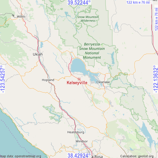
Kelseyville GPS coordinates[2]
38° 58' 40.62" North, 122° 50' 21.984" West
| Map corner | latitude | longitude |
|---|---|---|
| Upper-left | 39.52244°, | -123.54257° |
| Center: | 38.97795°, | -122.83944° |
| Lower-right: | 38.42924°, | -122.13632° |
| Map W x H: | 121.6×121.6 km | = 75.6×75.6mi |
| max Lat: | 71.29058° ⇑55.1% North |
| Kelseyville: | 38.97795° |
| min Lat: | ⇓44.9% South 19.06759° |
| min Long | Kelseyville | max Long |
| -171.73463° | -122.83944° | -66.98998° |
| W 2.4%⇐ | ⇒97.6% E |
Elevation
Elevation of Kelseyville is 422 m = 1385 ft, and this is 127.2 m = 417 ft above average elevation for this country.
| Max E: |
3189 m = 10463 ft | 15.1% |
| Kelseyville | 422 m 1385 ft | |
| Avg. | 294.8 m = 967 ft | |
Min E: |
-60 m = -197 ft | 84.9% |
See also: United States elevation on elevation.city.
Geographical zone
Kelseyville is located in North temperate zone (between Tropic of Cancer and the Arctic Circle). Distance of this Northern Tropic circle is 1728 km =1073.7 mi to South.| Distance of | km | miles | from Kelseyville |
|---|---|---|---|
| North Pole | 5673.1 | 3525.1 | to North |
| Arctic Circle | 3067.2 | 1905.9 | to North |
| Tropic Cancer | 1728 | 1073.7 | to South |
| Equator | 4333.9 | 2693 | to South |


Nearby cities:
15 places around Kelseyville: (largest is in red/bold)
• Clear Lake Riviera
10.6 km =6.6 mi,  104°
104°
• Clearlake
18.5 km =11.5 mi, 96°
• Clearlake Oaks
15.4 km =9.6 mi,  69°
69°
• Cloverdale
24.6 km =15.3 mi,  218°
218°
• Cobb
20 km =12.4 mi,  149°
149°
• Geyserville
30.5 km =19 mi,  190°
190°
• Hidden Valley Lake
30.8 km =19.1 mi,  127°
127°
• Hopland
23.9 km =14.9 mi,  268°
268°
• Lakeport
9.8 km =6.1 mi,  317°
317°
• Lower Lake
21.2 km =13.2 mi,  110°
110°
• Lucerne
13 km =8.1 mi,  16°
16°
• Nice
16.2 km =10.1 mi,  357°
357°
• North Lakeport
13.5 km =8.4 mi,  335°
335°
• Soda Bay
5 km =3.1 mi,  59°
59°
• Upper Lake
21.6 km =13.4 mi, 343°
Sources, notices
• [Note1] Compared only with cities in United States existing in our database
• [Src1] Map data: © OpenStreetMap contributors (CC-BY-SA)
• [Src2] Other city data from geonames.org with taken over terms of usage.
• [Src3] Geographical zone / Annual Mean Temperature by Robert A. Rohde @ Wikipedia
