Upper Lake geodata
Upper Lake (California) is a populated place; located in United States in America/Los_Angeles (GMT-7) time zone. With population of 1,052 people, there are 15940 cities with bigger population in this country. Compared to other cities in United States, 53.3% of cities are located further ↑North; 97.7% of cities are located further →East and 84.3% of cities have lower elevation than Upper Lake. Note1


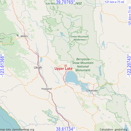
Upper Lake GPS coordinates[2]
39° 9' 52.596" North, 122° 54' 37.98" West
| Map corner | latitude | longitude |
|---|---|---|
| Upper-left | 39.70765°, | -123.61368° |
| Center: | 39.16461°, | -122.91055° |
| Lower-right: | 38.61734°, | -122.20743° |
| Map W x H: | 121.2×121.2 km | = 75.3×75.3mi |
| max Lat: | 71.29058° ⇑53.3% North |
| Upper Lake: | 39.16461° |
| min Lat: | ⇓46.7% South 19.06759° |
| min Long | Upper Lake | max Long |
| -171.73463° | -122.91055° | -66.98998° |
| W 2.3%⇐ | ⇒97.7% E |
Elevation
Elevation of Upper Lake is 410 m = 1345 ft, and this is 115.2 m = 378 ft above average elevation for this country.
| Max E: |
3189 m = 10463 ft | 15.7% |
| Upper Lake | 410 m 1345 ft | |
| Avg. | 294.8 m = 967 ft | |
Min E: |
-60 m = -197 ft | 84.3% |
See also: United States elevation on elevation.city.
Geographical zone
Upper Lake is located in North temperate zone (between Tropic of Cancer and the Arctic Circle). Distance of this Northern Tropic circle is 1748.8 km =1086.7 mi to South.| Distance of | km | miles | from Upper Lake |
|---|---|---|---|
| North Pole | 5652.4 | 3512.2 | to North |
| Arctic Circle | 3046.5 | 1893 | to North |
| Tropic Cancer | 1748.8 | 1086.7 | to South |
| Equator | 4354.7 | 2705.9 | to South |


Nearby cities:
15 places around Upper Lake: (largest is in red/bold)
• Calpella
26.4 km =16.4 mi,  286°
286°
• Clear Lake Riviera
28.6 km =17.8 mi,  145°
145°
• Clearlake
33.6 km =20.9 mi,  133°
133°
• Clearlake Oaks
25.7 km =16 mi, 126°
• Hopland
27.7 km =17.2 mi,  219°
219°
• Kelseyville
21.6 km =13.4 mi,  163°
163°
• Lakeport
13.5 km =8.4 mi,  181°
181°
• Lucerne
12.9 km =8 mi, 130°
• Nice
7.1 km =4.4 mi, 130°
• North Lakeport
8.5 km =5.3 mi, 176°
• Potter Valley
24.7 km =15.3 mi,  315°
315°
• Redwood Valley
27.7 km =17.2 mi, 293°
• Soda Bay
21 km =13 mi, 150°
• Talmage
22.5 km =14 mi,  261°
261°
• Ukiah
25.7 km =16 mi,  266°
266°
Sources, notices
• [Note1] Compared only with cities in United States existing in our database
• [Src1] Map data: © OpenStreetMap contributors (CC-BY-SA)
• [Src2] Other city data from geonames.org with taken over terms of usage.
• [Src3] Geographical zone / Annual Mean Temperature by Robert A. Rohde @ Wikipedia
