La Presa geodata
La Presa (California) is a populated place; located in United States in America/Los_Angeles (GMT-7) time zone. With population of 34,169 people, there are 1443 cities with bigger population in this country. Compared to other cities in United States, 86.4% of cities are located further ↑North; 89.7% of cities are located further →East and 68.8% of cities have higher elevation than La Presa. Note1


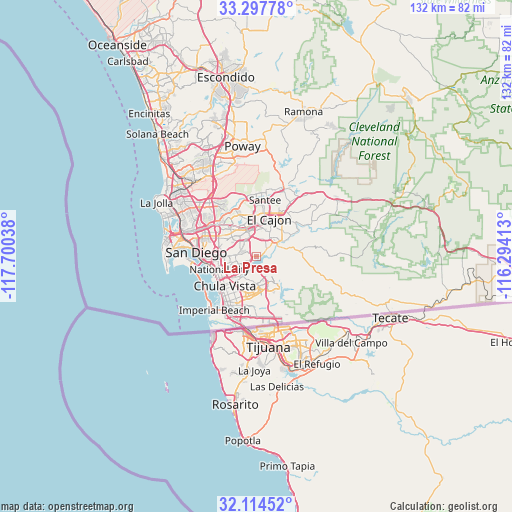
La Presa GPS coordinates[2]
32° 42' 29.196" North, 116° 59' 50.1" West
| Map corner | latitude | longitude |
|---|---|---|
| Upper-left | 33.29778°, | -117.70038° |
| Center: | 32.70811°, | -116.99725° |
| Lower-right: | 32.11452°, | -116.29413° |
| Map W x H: | 131.6×131.6 km | = 81.8×81.8mi |
| max Lat: | 71.29058° ⇑86.4% North |
| La Presa: | 32.70811° |
| min Lat: | ⇓13.6% South 19.06759° |
| min Long | La Presa | max Long |
| -171.73463° | -116.99725° | -66.98998° |
| W 10.3%⇐ | ⇒89.7% E |
Elevation
Elevation of La Presa is 108 m = 354 ft, and this is 186.8 m = 613 ft below average elevation for this country.
| Max E: |
3189 m = 10463 ft | 68.8% |
| Avg. | 294.8 m = 967 ft | |
| La Presa | 108 m = 354 ft | |
Min E: |
-60 m = -197 ft | 31.2% |
See also: United States elevation on elevation.city.
Geographical zone
La Presa is located in North temperate zone (between Tropic of Cancer and the Arctic Circle). Distance of this Northern Tropic circle is 1030.9 km =640.6 mi to South.| Distance of | km | miles | from La Presa |
|---|---|---|---|
| North Pole | 6370.3 | 3958.3 | to North |
| Arctic Circle | 3764.4 | 2339.1 | to North |
| Tropic Cancer | 1030.9 | 640.6 | to South |
| Equator | 3636.8 | 2259.8 | to South |


Nearby cities:
15 places around La Presa: (largest is in red/bold)
• Bonita
6.4 km =4 mi,  208°
208°
• Bostonia
12.4 km =7.7 mi,  27°
27°
• Casa de Oro-Mount Helix
6.8 km =4.2 mi,  23°
23°
• Chula Vista
11.1 km =6.9 mi,  227°
227°
• El Cajon
10.2 km =6.3 mi, 18°
• Granite Hills
13.7 km =8.5 mi,  39°
39°
• Jamul
11.4 km =7.1 mi,  85°
85°
• La Mesa
7.1 km =4.4 mi,  340°
340°
• Lemon Grove
5 km =3.1 mi,  320°
320°
• National City
10.1 km =6.3 mi,  250°
250°
• Rancho San Diego
7.2 km =4.5 mi,  53°
53°
• San Diego
15.7 km =9.8 mi,  273°
273°
• Santee
14.6 km =9.1 mi,  8°
8°
• Spring Valley
4.1 km =2.5 mi,  357°
357°
• Winter Gardens
14.9 km =9.3 mi, 23°
Sources, notices
• [Note1] Compared only with cities in United States existing in our database
• [Src1] Map data: © OpenStreetMap contributors (CC-BY-SA)
• [Src2] Other city data from geonames.org with taken over terms of usage.
• [Src3] Geographical zone / Annual Mean Temperature by Robert A. Rohde @ Wikipedia
