Santee geodata
Santee (California) is a populated place; located in United States in America/Los_Angeles (GMT-7) time zone. With population of 57,787 people, there are 788 cities with bigger population in this country. Compared to other cities in United States, 85.8% of cities are located further ↑North; 89.7% of cities are located further →East and 68.8% of cities have higher elevation than Santee. Note1


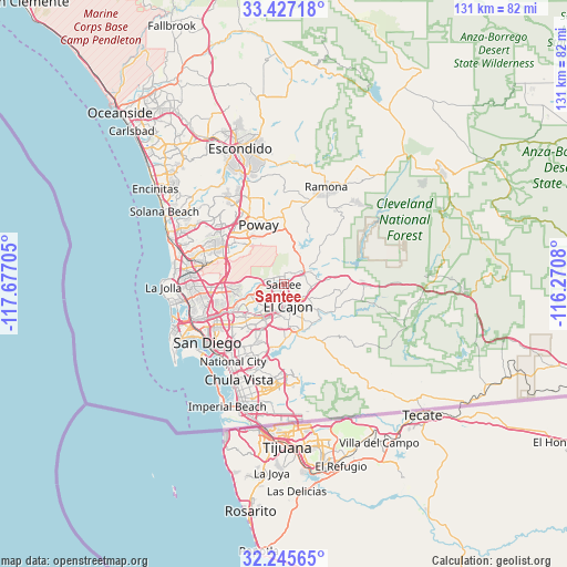
Santee GPS coordinates[2]
32° 50' 18.168" North, 116° 58' 26.112" West
| Map corner | latitude | longitude |
|---|---|---|
| Upper-left | 33.42718°, | -117.67705° |
| Center: | 32.83838°, | -116.97392° |
| Lower-right: | 32.24565°, | -116.2708° |
| Map W x H: | 131.4×131.4 km | = 81.6×81.6mi |
| max Lat: | 71.29058° ⇑85.8% North |
| Santee: | 32.83838° |
| min Lat: | ⇓14.2% South 19.06759° |
| min Long | Santee | max Long |
| -171.73463° | -116.97392° | -66.98998° |
| W 10.3%⇐ | ⇒89.7% E |
Elevation
Elevation of Santee is 108 m = 354 ft, and this is 186.8 m = 613 ft below average elevation for this country.
| Max E: |
3189 m = 10463 ft | 68.8% |
| Avg. | 294.8 m = 967 ft | |
| Santee | 108 m = 354 ft | |
Min E: |
-60 m = -197 ft | 31.2% |
See also: Santee elevation on elevation.city.
Geographical zone
Santee is located in North temperate zone (between Tropic of Cancer and the Arctic Circle). Distance of this Northern Tropic circle is 1045.4 km =649.6 mi to South.| Distance of | km | miles | from Santee |
|---|---|---|---|
| North Pole | 6355.8 | 3949.3 | to North |
| Arctic Circle | 3749.9 | 2330.1 | to North |
| Tropic Cancer | 1045.4 | 649.6 | to South |
| Equator | 3651.3 | 2268.8 | to South |


Nearby cities:
15 places around Santee: (largest is in red/bold)
• Bostonia
4.9 km =3 mi,  134°
134°
• Casa de Oro-Mount Helix
8.3 km =5.2 mi,  176°
176°
• Crest
10.5 km =6.5 mi,  109°
109°
• El Cajon
5 km =3.1 mi,  167°
167°
• Eucalyptus Hills
5.3 km =3.3 mi,  28°
28°
• Granite Hills
7.6 km =4.7 mi,  121°
121°
• Harbison Canyon
13.6 km =8.5 mi,  98°
98°
• La Mesa
9.1 km =5.7 mi,  210°
210°
• La Presa
14.6 km =9.1 mi,  188°
188°
• Lakeside
5.3 km =3.3 mi,  66°
66°
• Lemon Grove
11.9 km =7.4 mi, 206°
• Poway
15 km =9.3 mi,  337°
337°
• Rancho San Diego
10.8 km =6.7 mi,  160°
160°
• Spring Valley
10.7 km =6.6 mi, 192°
• Winter Gardens
3.9 km =2.4 mi, 101°
Sources, notices
• [Note1] Compared only with cities in United States existing in our database
• [Src1] Map data: © OpenStreetMap contributors (CC-BY-SA)
• [Src2] Other city data from geonames.org with taken over terms of usage.
• [Src3] Geographical zone / Annual Mean Temperature by Robert A. Rohde @ Wikipedia
