La Puente geodata
La Puente (California) is a populated place; located in United States in America/Los_Angeles (GMT-7) time zone. With population of 40,745 people, there are 1187 cities with bigger population in this country. Compared to other cities in United States, 80.1% of cities are located further ↑North; 90.8% of cities are located further →East and 68.9% of cities have higher elevation than La Puente. Note1


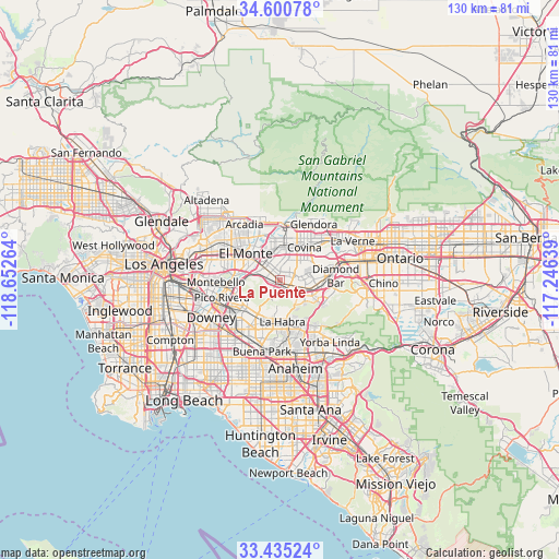
La Puente GPS coordinates[2]
34° 1' 12.036" North, 117° 56' 58.236" West
| Map corner | latitude | longitude |
|---|---|---|
| Upper-left | 34.60078°, | -118.65264° |
| Center: | 34.02001°, | -117.94951° |
| Lower-right: | 33.43524°, | -117.24639° |
| Map W x H: | 129.6×129.6 km | = 80.5×80.5mi |
| max Lat: | 71.29058° ⇑80.1% North |
| La Puente: | 34.02001° |
| min Lat: | ⇓19.9% South 19.06759° |
| min Long | La Puente | max Long |
| -171.73463° | -117.94951° | -66.98998° |
| W 9.2%⇐ | ⇒90.8% E |
Elevation
Elevation of La Puente is 107 m = 351 ft, and this is 187.8 m = 616 ft below average elevation for this country.
| Max E: |
3189 m = 10463 ft | 68.9% |
| Avg. | 294.8 m = 967 ft | |
| La Puente | 107 m = 351 ft | |
Min E: |
-60 m = -197 ft | 31.1% |
See also: La Puente elevation on elevation.city.
Geographical zone
La Puente is located in North temperate zone (between Tropic of Cancer and the Arctic Circle). Distance of this Northern Tropic circle is 1176.8 km =731.2 mi to South.| Distance of | km | miles | from La Puente |
|---|---|---|---|
| North Pole | 6224.4 | 3867.7 | to North |
| Arctic Circle | 3618.5 | 2248.4 | to North |
| Tropic Cancer | 1176.8 | 731.2 | to South |
| Equator | 3782.7 | 2350.5 | to South |


Nearby cities:
15 places around La Puente: (largest is in red/bold)
• Avocado Heights
4.2 km =2.6 mi,  295°
295°
• Baldwin Park
7.3 km =4.5 mi,  351°
351°
• Covina
9.5 km =5.9 mi,  35°
35°
• El Monte
9 km =5.6 mi,  306°
306°
• Hacienda Heights
3.5 km =2.2 mi,  210°
210°
• La Habra Heights
6.6 km =4.1 mi,  180°
180°
• Rowland Heights
6.4 km =4 mi,  140°
140°
• South El Monte
9.6 km =6 mi,  291°
291°
• South San Jose Hills
4.2 km =2.6 mi,  101°
101°
• Valinda
2.9 km =1.8 mi,  10°
10°
• Vincent
9 km =5.6 mi,  15°
15°
• Walnut
7.8 km =4.8 mi,  89°
89°
• West Covina
5.5 km =3.4 mi, 10°
• West Puente Valley
3.9 km =2.4 mi,  333°
333°
• Whittier
8.9 km =5.5 mi,  239°
239°
Sources, notices
• [Note1] Compared only with cities in United States existing in our database
• [Src1] Map data: © OpenStreetMap contributors (CC-BY-SA)
• [Src2] Other city data from geonames.org with taken over terms of usage.
• [Src3] Geographical zone / Annual Mean Temperature by Robert A. Rohde @ Wikipedia
