Whittier geodata
Whittier (California) is a populated place; located in United States in America/Los_Angeles (GMT-7) time zone. With population of 87,438 people, there are 432 cities with bigger population in this country. Compared to other cities in United States, 80.4% of cities are located further ↑North; 90.9% of cities are located further →East and 67.1% of cities have higher elevation than Whittier. Note1


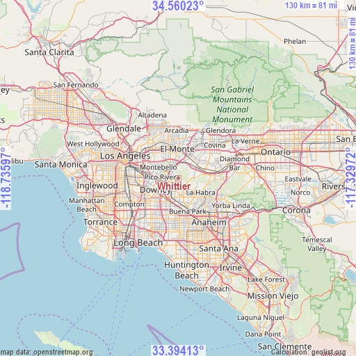
Whittier GPS coordinates[2]
33° 58' 45.048" North, 118° 1' 58.224" West
| Map corner | latitude | longitude |
|---|---|---|
| Upper-left | 34.56023°, | -118.73597° |
| Center: | 33.97918°, | -118.03284° |
| Lower-right: | 33.39413°, | -117.32972° |
| Map W x H: | 129.7×129.7 km | = 80.6×80.6mi |
| max Lat: | 71.29058° ⇑80.4% North |
| Whittier: | 33.97918° |
| min Lat: | ⇓19.6% South 19.06759° |
| min Long | Whittier | max Long |
| -171.73463° | -118.03284° | -66.98998° |
| W 9.1%⇐ | ⇒90.9% E |
Elevation
Elevation of Whittier is 117 m = 384 ft, and this is 177.8 m = 583 ft below average elevation for this country.
| Max E: |
3189 m = 10463 ft | 67.1% |
| Avg. | 294.8 m = 967 ft | |
| Whittier | 117 m = 384 ft | |
Min E: |
-60 m = -197 ft | 32.9% |
See also: Whittier elevation on elevation.city.
Geographical zone
Whittier is located in North temperate zone (between Tropic of Cancer and the Arctic Circle). Distance of this Northern Tropic circle is 1172.2 km =728.4 mi to South.| Distance of | km | miles | from Whittier |
|---|---|---|---|
| North Pole | 6228.9 | 3870.5 | to North |
| Arctic Circle | 3623 | 2251.2 | to North |
| Tropic Cancer | 1172.2 | 728.4 | to South |
| Equator | 3778.1 | 2347.6 | to South |


Nearby cities:
15 places around Whittier: (largest is in red/bold)
• Avocado Heights
7.4 km =4.6 mi,  31°
31°
• East La Mirada
7.3 km =4.5 mi,  146°
146°
• Hacienda Heights
6.1 km =3.8 mi,  75°
75°
• La Habra
9.6 km =6 mi,  123°
123°
• La Habra Heights
7.9 km =4.9 mi,  105°
105°
• La Mirada
7.2 km =4.5 mi,  164°
164°
• La Puente
8.9 km =5.5 mi,  59°
59°
• Montebello
7.5 km =4.7 mi,  296°
296°
• Norwalk
9.7 km =6 mi,  207°
207°
• Pico Rivera
5.9 km =3.7 mi,  274°
274°
• Santa Fe Springs
6 km =3.7 mi,  233°
233°
• South El Monte
8.2 km =5.1 mi,  351°
351°
• South San Gabriel
9.6 km =6 mi,  323°
323°
• South Whittier
3.3 km =2.1 mi,  190°
190°
• West Whittier-Los Nietos
3.4 km =2.1 mi,  263°
263°
Sources, notices
• [Note1] Compared only with cities in United States existing in our database
• [Src1] Map data: © OpenStreetMap contributors (CC-BY-SA)
• [Src2] Other city data from geonames.org with taken over terms of usage.
• [Src3] Geographical zone / Annual Mean Temperature by Robert A. Rohde @ Wikipedia
