Lodi geodata
Lodi (California) is a populated place; located in United States in America/Los_Angeles (GMT-7) time zone. With population of 64,596 people, there are 671 cities with bigger population in this country. Compared to other cities in United States, 61% of cities are located further ↑North; 94.1% of cities are located further →East and 90.5% of cities have higher elevation than Lodi. Note1


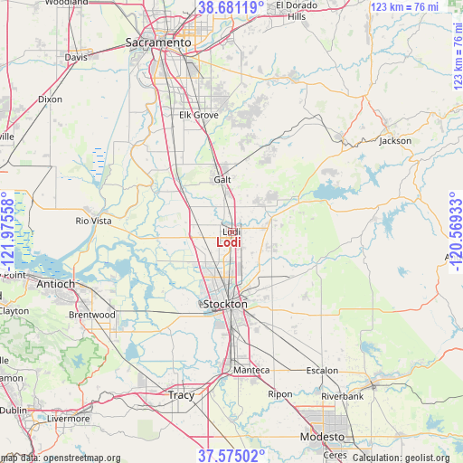
Lodi GPS coordinates[2]
38° 7' 48.72" North, 121° 16' 20.82" West
| Map corner | latitude | longitude |
|---|---|---|
| Upper-left | 38.68119°, | -121.97558° |
| Center: | 38.1302°, | -121.27245° |
| Lower-right: | 37.57502°, | -120.56933° |
| Map W x H: | 123×123 km | = 76.4×76.4mi |
| max Lat: | 71.29058° ⇑61% North |
| Lodi: | 38.1302° |
| min Lat: | ⇓39% South 19.06759° |
| min Long | Lodi | max Long |
| -171.73463° | -121.27245° | -66.98998° |
| W 5.9%⇐ | ⇒94.1% E |
Elevation
Elevation of Lodi is 15 m = 49 ft, and this is 279.8 m = 918 ft below average elevation for this country.
| Max E: |
3189 m = 10463 ft | 90.5% |
| Avg. | 294.8 m = 967 ft | |
| Lodi | 15 m = 49 ft | |
Min E: |
-60 m = -197 ft | 9.5% |
See also: Lodi elevation on elevation.city.
Geographical zone
Lodi is located in North temperate zone (between Tropic of Cancer and the Arctic Circle). Distance of this Northern Tropic circle is 1633.8 km =1015.2 mi to South.| Distance of | km | miles | from Lodi |
|---|---|---|---|
| North Pole | 5767.4 | 3583.7 | to North |
| Arctic Circle | 3161.5 | 1964.5 | to North |
| Tropic Cancer | 1633.8 | 1015.2 | to South |
| Equator | 4239.7 | 2634.4 | to South |


Nearby cities:
15 places around Lodi: (largest is in red/bold)
• August
16.9 km =10.5 mi,  176°
176°
• Collierville
9.4 km =5.8 mi,  1°
1°
• Country Club
18.9 km =11.7 mi,  198°
198°
• Dogtown
18.6 km =11.6 mi,  59°
59°
• Galt
14 km =8.7 mi,  350°
350°
• Garden Acres
18.9 km =11.7 mi,  168°
168°
• Herald
18.6 km =11.6 mi,  7°
7°
• Lincoln Village
14.7 km =9.1 mi, 199°
• Linden
20.5 km =12.7 mi,  126°
126°
• Lockeford
11.3 km =7 mi,  70°
70°
• Morada
10.5 km =6.5 mi, 167°
• Stockton
19.2 km =11.9 mi, 184°
• Thornton
17 km =10.6 mi,  308°
308°
• Waterloo
13 km =8.1 mi,  144°
144°
• Woodbridge
3.7 km =2.3 mi,  316°
316°
Sources, notices
• [Note1] Compared only with cities in United States existing in our database
• [Src1] Map data: © OpenStreetMap contributors (CC-BY-SA)
• [Src2] Other city data from geonames.org with taken over terms of usage.
• [Src3] Geographical zone / Annual Mean Temperature by Robert A. Rohde @ Wikipedia
