August geodata
August (California) is a populated place; located in United States in America/Los_Angeles (GMT-7) time zone. With population of 8,390 people, there are 5084 cities with bigger population in this country. Compared to other cities in United States, 61.7% of cities are located further ↑North; 94.1% of cities are located further →East and 94.8% of cities have higher elevation than August. Note1


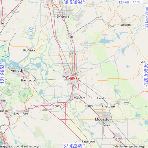
August GPS coordinates[2]
37° 58' 43.716" North, 121° 15' 43.812" West
| Map corner | latitude | longitude |
|---|---|---|
| Upper-left | 38.53094°, | -121.9653° |
| Center: | 37.97881°, | -121.26217° |
| Lower-right: | 37.42249°, | -120.55905° |
| Map W x H: | 123.2×123.2 km | = 76.6×76.6mi |
| max Lat: | 71.29058° ⇑61.7% North |
| August: | 37.97881° |
| min Lat: | ⇓38.3% South 19.06759° |
| min Long | August | max Long |
| -171.73463° | -121.26217° | -66.98998° |
| W 5.9%⇐ | ⇒94.1% E |
Elevation
Elevation of August is 9 m = 30 ft, and this is 285.8 m = 938 ft below average elevation for this country.
| Max E: |
3189 m = 10463 ft | 94.8% |
| Avg. | 294.8 m = 967 ft | |
| August | 9 m = 30 ft | |
Min E: |
-60 m = -197 ft | 5.2% |
See also: United States elevation on elevation.city.
Geographical zone
August is located in North temperate zone (between Tropic of Cancer and the Arctic Circle). Distance of this Northern Tropic circle is 1616.9 km =1004.7 mi to South.| Distance of | km | miles | from August |
|---|---|---|---|
| North Pole | 5784.2 | 3594.1 | to North |
| Arctic Circle | 3178.3 | 1974.9 | to North |
| Tropic Cancer | 1616.9 | 1004.7 | to South |
| Equator | 4222.8 | 2623.9 | to South |


Nearby cities:
15 places around August: (largest is in red/bold)
• Country Club
7 km =4.3 mi,  260°
260°
• French Camp
10.6 km =6.6 mi,  184°
184°
• Garden Acres
3.3 km =2.1 mi,  120°
120°
• Kennedy
5.5 km =3.4 mi,  171°
171°
• Lathrop
17.4 km =10.8 mi, 184°
• Lincoln Village
6.5 km =4 mi,  296°
296°
• Linden
16.3 km =10.1 mi,  73°
73°
• Lodi
16.9 km =10.5 mi,  356°
356°
• Manteca
20.6 km =12.8 mi, 168°
• Morada
6.8 km =4.2 mi,  12°
12°
• Peters
18.8 km =11.7 mi,  89°
89°
• Stockton
3.4 km =2.1 mi,  226°
226°
• Taft Mosswood
7.5 km =4.7 mi,  194°
194°
• Waterloo
9.1 km =5.7 mi,  46°
46°
• Woodbridge
19.8 km =12.3 mi,  350°
350°
Sources, notices
• [Note1] Compared only with cities in United States existing in our database
• [Src1] Map data: © OpenStreetMap contributors (CC-BY-SA)
• [Src2] Other city data from geonames.org with taken over terms of usage.
• [Src3] Geographical zone / Annual Mean Temperature by Robert A. Rohde @ Wikipedia
