Mokelumne Hill geodata
Mokelumne Hill (California) is a populated place; located in United States in America/Los_Angeles (GMT-7) time zone. With population of 646 people, there are 19209 cities with bigger population in this country. Compared to other cities in United States, 59.9% of cities are located further ↑North; 93.5% of cities are located further →East and 86.3% of cities have lower elevation than Mokelumne Hill. Note1


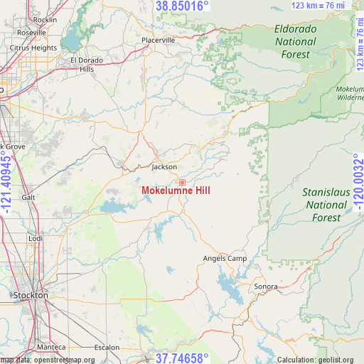
Mokelumne Hill GPS coordinates[2]
38° 18' 1.692" North, 120° 42' 22.752" West
| Map corner | latitude | longitude |
|---|---|---|
| Upper-left | 38.85016°, | -121.40945° |
| Center: | 38.30047°, | -120.70632° |
| Lower-right: | 37.74658°, | -120.0032° |
| Map W x H: | 122.7×122.7 km | = 76.2×76.2mi |
| max Lat: | 71.29058° ⇑59.9% North |
| Mokelumne Hill: | 38.30047° |
| min Lat: | ⇓40.1% South 19.06759° |
| min Long | Mokelumne Hill | max Long |
| -171.73463° | -120.70632° | -66.98998° |
| W 6.5%⇐ | ⇒93.5% E |
Elevation
Elevation of Mokelumne Hill is 449 m = 1473 ft, and this is 154.2 m = 506 ft above average elevation for this country.
| Max E: |
3189 m = 10463 ft | 13.7% |
| Mokelumne Hill | 449 m 1473 ft | |
| Avg. | 294.8 m = 967 ft | |
Min E: |
-60 m = -197 ft | 86.3% |
See also: United States elevation on elevation.city.
Geographical zone
Mokelumne Hill is located in North temperate zone (between Tropic of Cancer and the Arctic Circle). Distance of this Northern Tropic circle is 1652.7 km =1026.9 mi to South.| Distance of | km | miles | from Mokelumne Hill |
|---|---|---|---|
| North Pole | 5748.4 | 3571.9 | to North |
| Arctic Circle | 3142.6 | 1952.7 | to North |
| Tropic Cancer | 1652.7 | 1026.9 | to South |
| Equator | 4258.6 | 2646.2 | to South |


Nearby cities:
15 places around Mokelumne Hill: (largest is in red/bold)
• Buckhorn
22.9 km =14.2 mi,  42°
42°
• Camanche North Shore
22.5 km =14 mi,  253°
253°
• Camanche Village
23.5 km =14.6 mi,  261°
261°
• Ione
20.6 km =12.8 mi,  286°
286°
• Jackson
8 km =5 mi,  312°
312°
• Mountain Ranch
16.5 km =10.3 mi,  119°
119°
• Pine Grove
13.2 km =8.2 mi,  18°
18°
• Pioneer
18.7 km =11.6 mi, 38°
• Plymouth
23.5 km =14.6 mi,  329°
329°
• Rancho Calaveras
23.4 km =14.5 mi,  214°
214°
• Red Corral
15.2 km =9.4 mi, 35°
• San Andreas
11.8 km =7.3 mi,  169°
169°
• Sutter Creek
13.3 km =8.3 mi,  320°
320°
• Valley Springs
16.2 km =10.1 mi,  221°
221°
• West Point
19.1 km =11.9 mi,  54°
54°
Sources, notices
• [Note1] Compared only with cities in United States existing in our database
• [Src1] Map data: © OpenStreetMap contributors (CC-BY-SA)
• [Src2] Other city data from geonames.org with taken over terms of usage.
• [Src3] Geographical zone / Annual Mean Temperature by Robert A. Rohde @ Wikipedia
