Plymouth geodata
Plymouth (California) is a populated place; located in United States in America/Los_Angeles (GMT-7) time zone. With population of 960 people, there are 16566 cities with bigger population in this country. Compared to other cities in United States, 58.9% of cities are located further ↑North; 93.6% of cities are located further →East and 77.4% of cities have lower elevation than Plymouth. Note1


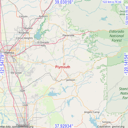
Plymouth GPS coordinates[2]
38° 28' 54.66" North, 120° 50' 40.776" West
| Map corner | latitude | longitude |
|---|---|---|
| Upper-left | 39.03016°, | -121.54779° |
| Center: | 38.48185°, | -120.84466° |
| Lower-right: | 37.92934°, | -120.14154° |
| Map W x H: | 122.4×122.4 km | = 76.1×76.1mi |
| max Lat: | 71.29058° ⇑58.9% North |
| Plymouth: | 38.48185° |
| min Lat: | ⇓41.1% South 19.06759° |
| min Long | Plymouth | max Long |
| -171.73463° | -120.84466° | -66.98998° |
| W 6.4%⇐ | ⇒93.6% E |
Elevation
Elevation of Plymouth is 331 m = 1086 ft, and this is 36.2 m = 119 ft above average elevation for this country.
| Max E: |
3189 m = 10463 ft | 22.6% |
| Plymouth | 331 m 1086 ft | |
| Avg. | 294.8 m = 967 ft | |
Min E: |
-60 m = -197 ft | 77.4% |
See also: United States elevation on elevation.city.
Geographical zone
Plymouth is located in North temperate zone (between Tropic of Cancer and the Arctic Circle). Distance of this Northern Tropic circle is 1672.9 km =1039.5 mi to South.| Distance of | km | miles | from Plymouth |
|---|---|---|---|
| North Pole | 5728.3 | 3559.4 | to North |
| Arctic Circle | 3122.4 | 1940.2 | to North |
| Tropic Cancer | 1672.9 | 1039.5 | to South |
| Equator | 4278.8 | 2658.7 | to South |


Nearby cities:
15 places around Plymouth: (largest is in red/bold)
• Buckhorn
27.7 km =17.2 mi,  96°
96°
• Camanche Village
26.1 km =16.2 mi,  205°
205°
• Cameron Park
24.2 km =15 mi,  329°
329°
• Deer Park
22.3 km =13.9 mi,  4°
4°
• Diamond Springs
23.8 km =14.8 mi,  6°
6°
• Ione
16.3 km =10.1 mi, 208°
• Jackson
16 km =9.9 mi,  157°
157°
• Mokelumne Hill
23.5 km =14.6 mi,  149°
149°
• Pine Grove
17.9 km =11.1 mi,  115°
115°
• Pioneer
24.4 km =15.2 mi, 103°
• Placerville
27.8 km =17.3 mi, 8°
• Rancho Murieta
21.9 km =13.6 mi,  275°
275°
• Red Corral
22.2 km =13.8 mi,  110°
110°
• Shingle Springs
21.6 km =13.4 mi,  340°
340°
• Sutter Creek
10.5 km =6.5 mi, 159°
Sources, notices
• [Note1] Compared only with cities in United States existing in our database
• [Src1] Map data: © OpenStreetMap contributors (CC-BY-SA)
• [Src2] Other city data from geonames.org with taken over terms of usage.
• [Src3] Geographical zone / Annual Mean Temperature by Robert A. Rohde @ Wikipedia
