Orcutt geodata
Orcutt (California) is a populated place; located in United States in America/Los_Angeles (GMT-7) time zone. With population of 28,905 people, there are 1726 cities with bigger population in this country. Compared to other cities in United States, 76.1% of cities are located further ↑North; 93.2% of cities are located further →East and 67.9% of cities have higher elevation than Orcutt. Note1


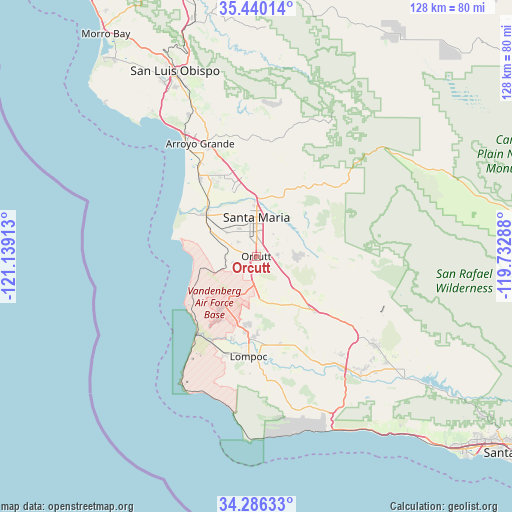
Orcutt GPS coordinates[2]
34° 51' 54.936" North, 120° 26' 9.6" West
| Map corner | latitude | longitude |
|---|---|---|
| Upper-left | 35.44014°, | -121.13913° |
| Center: | 34.86526°, | -120.436° |
| Lower-right: | 34.28633°, | -119.73288° |
| Map W x H: | 128.3×128.3 km | = 79.7×79.7mi |
| max Lat: | 71.29058° ⇑76.1% North |
| Orcutt: | 34.86526° |
| min Lat: | ⇓23.9% South 19.06759° |
| min Long | Orcutt | max Long |
| -171.73463° | -120.436° | -66.98998° |
| W 6.8%⇐ | ⇒93.2% E |
Elevation
Elevation of Orcutt is 113 m = 371 ft, and this is 181.8 m = 596 ft below average elevation for this country.
| Max E: |
3189 m = 10463 ft | 67.9% |
| Avg. | 294.8 m = 967 ft | |
| Orcutt | 113 m = 371 ft | |
Min E: |
-60 m = -197 ft | 32.1% |
See also: United States elevation on elevation.city.
Geographical zone
Orcutt is located in North temperate zone (between Tropic of Cancer and the Arctic Circle). Distance of this Northern Tropic circle is 1270.7 km =789.6 mi to South.| Distance of | km | miles | from Orcutt |
|---|---|---|---|
| North Pole | 6130.4 | 3809.3 | to North |
| Arctic Circle | 3524.5 | 2190 | to North |
| Tropic Cancer | 1270.7 | 789.6 | to South |
| Equator | 3876.7 | 2408.9 | to South |


Nearby cities:
15 places around Orcutt: (largest is in red/bold)
• Arroyo Grande
31.5 km =19.6 mi,  333°
333°
• Blacklake
22.5 km =14 mi,  335°
335°
• Callender
25.5 km =15.8 mi, 325°
• Grover Beach
33.1 km =20.6 mi, 329°
• Guadalupe
17.1 km =10.6 mi,  313°
313°
• Lompoc
25.2 km =15.7 mi,  184°
184°
• Los Alamos
19.7 km =12.2 mi,  133°
133°
• Los Berros
25.7 km =16 mi, 337°
• Mission Hills
19.9 km =12.4 mi, 180°
• Nipomo
20.1 km =12.5 mi,  349°
349°
• Oceano
30.5 km =19 mi, 328°
• Santa Maria
9.8 km =6.1 mi,  0°
0°
• Vandenberg Air Force Base
15 km =9.3 mi,  209°
209°
• Vandenberg Village
17.7 km =11 mi,  189°
189°
• Woodlands
21.1 km =13.1 mi, 329°
Sources, notices
• [Note1] Compared only with cities in United States existing in our database
• [Src1] Map data: © OpenStreetMap contributors (CC-BY-SA)
• [Src2] Other city data from geonames.org with taken over terms of usage.
• [Src3] Geographical zone / Annual Mean Temperature by Robert A. Rohde @ Wikipedia
