Richmond geodata
Richmond (California) is a populated place; located in United States in America/Los_Angeles (GMT-7) time zone. With population of 109,708 people, there are 307 cities with bigger population in this country. Compared to other cities in United States, 62% of cities are located further ↑North; 96.2% of cities are located further →East and 92.1% of cities have higher elevation than Richmond. Note1


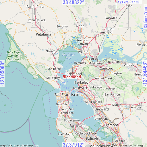
Richmond GPS coordinates[2]
37° 56' 8.736" North, 122° 20' 51.9" West
| Map corner | latitude | longitude |
|---|---|---|
| Upper-left | 38.48822°, | -123.05088° |
| Center: | 37.93576°, | -122.34775° |
| Lower-right: | 37.37912°, | -121.64463° |
| Map W x H: | 123.3×123.3 km | = 76.6×76.6mi |
| max Lat: | 71.29058° ⇑62% North |
| Richmond: | 37.93576° |
| min Lat: | ⇓38% South 19.06759° |
| min Long | Richmond | max Long |
| -171.73463° | -122.34775° | -66.98998° |
| W 3.8%⇐ | ⇒96.2% E |
Elevation
Elevation of Richmond is 12 m = 39 ft, and this is 282.8 m = 928 ft below average elevation for this country.
| Max E: |
3189 m = 10463 ft | 92.1% |
| Avg. | 294.8 m = 967 ft | |
| Richmond | 12 m = 39 ft | |
Min E: |
-60 m = -197 ft | 7.9% |
See also: Richmond elevation on elevation.city.
Geographical zone
Richmond is located in North temperate zone (between Tropic of Cancer and the Arctic Circle). Distance of this Northern Tropic circle is 1612.1 km =1001.7 mi to South.| Distance of | km | miles | from Richmond |
|---|---|---|---|
| North Pole | 5789 | 3597.1 | to North |
| Arctic Circle | 3183.1 | 1977.9 | to North |
| Tropic Cancer | 1612.1 | 1001.7 | to South |
| Equator | 4218.1 | 2621 | to South |


Nearby cities:
15 places around Richmond: (largest is in red/bold)
• Albany
7 km =4.3 mi,  141°
141°
• Bayview
8.3 km =5.2 mi,  17°
17°
• Berkeley
9.7 km =6 mi, 137°
• East Richmond Heights
3.2 km =2 mi,  71°
71°
• El Cerrito
3.9 km =2.4 mi,  125°
125°
• El Sobrante
6.5 km =4 mi,  45°
45°
• Hercules
10.4 km =6.5 mi,  29°
29°
• Kensington
6.6 km =4.1 mi,  115°
115°
• Montalvin
6.8 km =4.2 mi,  11°
11°
• North Richmond
3.1 km =1.9 mi,  325°
325°
• Pinole
8.7 km =5.4 mi, 29°
• Rollingwood
3.6 km =2.2 mi, 25°
• San Pablo
2.9 km =1.8 mi,  3°
3°
• Tara Hills
7 km =4.3 mi, 23°
• Tiburon
11.8 km =7.3 mi,  234°
234°
Sources, notices
• [Note1] Compared only with cities in United States existing in our database
• [Src1] Map data: © OpenStreetMap contributors (CC-BY-SA)
• [Src2] Other city data from geonames.org with taken over terms of usage.
• [Src3] Geographical zone / Annual Mean Temperature by Robert A. Rohde @ Wikipedia
