Berkeley geodata
Berkeley (California) is a populated place; located in United States in America/Los_Angeles (GMT-7) time zone. With population of 120,972 people, there are 260 cities with bigger population in this country. Compared to other cities in United States, 62.3% of cities are located further ↑North; 95.9% of cities are located further →East and 78.2% of cities have higher elevation than Berkeley. Note1


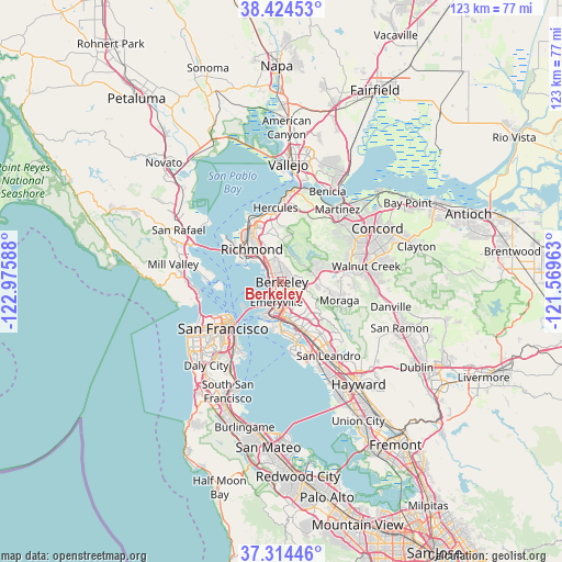
Berkeley GPS coordinates[2]
37° 52' 17.724" North, 122° 16' 21.9" West
| Map corner | latitude | longitude |
|---|---|---|
| Upper-left | 38.42453°, | -122.97588° |
| Center: | 37.87159°, | -122.27275° |
| Lower-right: | 37.31446°, | -121.56963° |
| Map W x H: | 123.4×123.4 km | = 76.7×76.7mi |
| max Lat: | 71.29058° ⇑62.3% North |
| Berkeley: | 37.87159° |
| min Lat: | ⇓37.7% South 19.06759° |
| min Long | Berkeley | max Long |
| -171.73463° | -122.27275° | -66.98998° |
| W 4.1%⇐ | ⇒95.9% E |
Elevation
Elevation of Berkeley is 55 m = 180 ft, and this is 239.8 m = 787 ft below average elevation for this country.
| Max E: |
3189 m = 10463 ft | 78.2% |
| Avg. | 294.8 m = 967 ft | |
| Berkeley | 55 m = 180 ft | |
Min E: |
-60 m = -197 ft | 21.8% |
See also: Berkeley elevation on elevation.city.
Geographical zone
Berkeley is located in North temperate zone (between Tropic of Cancer and the Arctic Circle). Distance of this Northern Tropic circle is 1605 km =997.3 mi to South.| Distance of | km | miles | from Berkeley |
|---|---|---|---|
| North Pole | 5796.1 | 3601.5 | to North |
| Arctic Circle | 3190.2 | 1982.3 | to North |
| Tropic Cancer | 1605 | 997.3 | to South |
| Equator | 4210.9 | 2616.5 | to South |


Nearby cities:
15 places around Berkeley: (largest is in red/bold)
• Alameda
12.1 km =7.5 mi,  166°
166°
• Albany
2.8 km =1.7 mi,  307°
307°
• East Richmond Heights
8.9 km =5.5 mi,  336°
336°
• El Cerrito
6 km =3.7 mi,  325°
325°
• El Sobrante
11.9 km =7.4 mi,  350°
350°
• Emeryville
4.6 km =2.9 mi,  193°
193°
• Kensington
4.4 km =2.7 mi, 351°
• Moraga
13.2 km =8.2 mi,  107°
107°
• North Richmond
12.8 km =8 mi,  319°
319°
• Oakland
7.5 km =4.7 mi,  178°
178°
• Orinda
8.2 km =5.1 mi,  85°
85°
• Piedmont
6.4 km =4 mi,  145°
145°
• Richmond
9.7 km =6 mi, 317°
• Rollingwood
11.6 km =7.2 mi, 334°
• San Pablo
11.9 km =7.4 mi, 327°
Sources, notices
• [Note1] Compared only with cities in United States existing in our database
• [Src1] Map data: © OpenStreetMap contributors (CC-BY-SA)
• [Src2] Other city data from geonames.org with taken over terms of usage.
• [Src3] Geographical zone / Annual Mean Temperature by Robert A. Rohde @ Wikipedia
