Santa Cruz geodata
Santa Cruz (California) is a seat of a second-order administrative division; located in United States in America/Los_Angeles (GMT-7) time zone. With population of 64,220 people, there are 674 cities with bigger population in this country. Compared to other cities in United States, 66.3% of cities are located further ↑North; 95.1% of cities are located further →East and 95.7% of cities have higher elevation than Santa Cruz. Note1


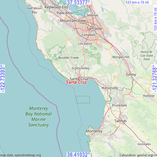
Santa Cruz GPS coordinates[2]
36° 58' 26.832" North, 122° 1' 50.88" West
| Map corner | latitude | longitude |
|---|---|---|
| Upper-left | 37.53377°, | -122.73393° |
| Center: | 36.97412°, | -122.0308° |
| Lower-right: | 36.41032°, | -121.32768° |
| Map W x H: | 124.9×124.9 km | = 77.6×77.6mi |
| max Lat: | 71.29058° ⇑66.3% North |
| Santa Cruz: | 36.97412° |
| min Lat: | ⇓33.7% South 19.06759° |
| min Long | Santa Cruz | max Long |
| -171.73463° | -122.0308° | -66.98998° |
| W 4.9%⇐ | ⇒95.1% E |
Elevation
Elevation of Santa Cruz is 8 m = 26 ft, and this is 286.8 m = 941 ft below average elevation for this country.
| Max E: |
3189 m = 10463 ft | 95.7% |
| Avg. | 294.8 m = 967 ft | |
| Santa Cruz | 8 m = 26 ft | |
Min E: |
-60 m = -197 ft | 4.3% |
See also: Santa Cruz elevation on elevation.city.
Geographical zone
Santa Cruz is located in North temperate zone (between Tropic of Cancer and the Arctic Circle). Distance of this Northern Tropic circle is 1505.2 km =935.3 mi to South.| Distance of | km | miles | from Santa Cruz |
|---|---|---|---|
| North Pole | 5895.9 | 3663.5 | to North |
| Arctic Circle | 3290 | 2044.3 | to North |
| Tropic Cancer | 1505.2 | 935.3 | to South |
| Equator | 4111.1 | 2554.5 | to South |


Nearby cities:
15 places around Santa Cruz: (largest is in red/bold)
• Aptos
11.7 km =7.3 mi,  88°
88°
• Ben Lomond
13.7 km =8.5 mi,  338°
338°
• Bonny Doon
13 km =8.1 mi,  305°
305°
• Capitola
6.9 km =4.3 mi, 88°
• Felton
9.4 km =5.8 mi, 336°
• Live Oak
4.6 km =2.9 mi,  76°
76°
• Mount Hermon
8.9 km =5.5 mi, 343°
• Opal Cliffs
6.1 km =3.8 mi,  104°
104°
• Pasatiempo
3.4 km =2.1 mi,  7°
7°
• Rio Del Mar
11.6 km =7.2 mi, 93°
• Scotts Valley
8.7 km =5.4 mi, 9°
• Seacliff
10.2 km =6.3 mi, 90°
• Soquel
6.8 km =4.2 mi, 76°
• Twin Lakes
3 km =1.9 mi, 104°
• Zayante
13.1 km =8.1 mi,  355°
355°
Sources, notices
• [Note1] Compared only with cities in United States existing in our database
• [Src1] Map data: © OpenStreetMap contributors (CC-BY-SA)
• [Src2] Other city data from geonames.org with taken over terms of usage.
• [Src3] Geographical zone / Annual Mean Temperature by Robert A. Rohde @ Wikipedia
