Zayante geodata
Zayante (California) is a populated place; located in United States in America/Los_Angeles (GMT-7) time zone. With population of 705 people, there are 18626 cities with bigger population in this country. Compared to other cities in United States, 65.7% of cities are located further ↑North; 95.2% of cities are located further →East and 59.9% of cities have higher elevation than Zayante. Note1


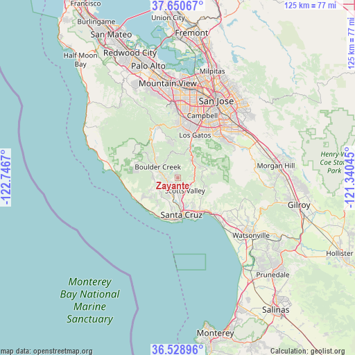
Zayante GPS coordinates[2]
37° 5' 30.804" North, 122° 2' 36.852" West
| Map corner | latitude | longitude |
|---|---|---|
| Upper-left | 37.65067°, | -122.7467° |
| Center: | 37.09189°, | -122.04357° |
| Lower-right: | 36.52896°, | -121.34045° |
| Map W x H: | 124.7×124.7 km | = 77.5×77.5mi |
| max Lat: | 71.29058° ⇑65.7% North |
| Zayante: | 37.09189° |
| min Lat: | ⇓34.3% South 19.06759° |
| min Long | Zayante | max Long |
| -171.73463° | -122.04357° | -66.98998° |
| W 4.8%⇐ | ⇒95.2% E |
Elevation
Elevation of Zayante is 155 m = 509 ft, and this is 139.8 m = 459 ft below average elevation for this country.
| Max E: |
3189 m = 10463 ft | 59.9% |
| Avg. | 294.8 m = 967 ft | |
| Zayante | 155 m = 509 ft | |
Min E: |
-60 m = -197 ft | 40.1% |
See also: United States elevation on elevation.city.
Geographical zone
Zayante is located in North temperate zone (between Tropic of Cancer and the Arctic Circle). Distance of this Northern Tropic circle is 1518.3 km =943.4 mi to South.| Distance of | km | miles | from Zayante |
|---|---|---|---|
| North Pole | 5882.8 | 3655.4 | to North |
| Arctic Circle | 3276.9 | 2036.2 | to North |
| Tropic Cancer | 1518.3 | 943.4 | to South |
| Equator | 4124.2 | 2562.7 | to South |


Nearby cities:
15 places around Zayante: (largest is in red/bold)
• Ben Lomond
3.8 km =2.4 mi,  265°
265°
• Bonny Doon
11 km =6.8 mi,  239°
239°
• Boulder Creek
7.9 km =4.9 mi,  298°
298°
• Brookdale
5.8 km =3.6 mi,  286°
286°
• Capitola
15.2 km =9.4 mi,  148°
148°
• Felton
5.2 km =3.2 mi,  210°
210°
• Lexington Hills
10.2 km =6.3 mi,  37°
37°
• Live Oak
13.3 km =8.3 mi,  155°
155°
• Lompico
1.7 km =1.1 mi,  331°
331°
• Mount Hermon
4.7 km =2.9 mi,  196°
196°
• Pasatiempo
9.9 km =6.2 mi,  170°
170°
• Santa Cruz
13.1 km =8.1 mi,  175°
175°
• Scotts Valley
5.2 km =3.2 mi, 150°
• Soquel
13.9 km =8.6 mi, 146°
• Twin Lakes
14.4 km =8.9 mi, 163°
Sources, notices
• [Note1] Compared only with cities in United States existing in our database
• [Src1] Map data: © OpenStreetMap contributors (CC-BY-SA)
• [Src2] Other city data from geonames.org with taken over terms of usage.
• [Src3] Geographical zone / Annual Mean Temperature by Robert A. Rohde @ Wikipedia
