Stinson Beach geodata
Stinson Beach (California) is a populated place; located in United States in America/Los_Angeles (GMT-7) time zone. With population of 632 people, there are 19334 cities with bigger population in this country. Compared to other cities in United States, 62.2% of cities are located further ↑North; 97.1% of cities are located further →East and 85.4% of cities have higher elevation than Stinson Beach. Note1


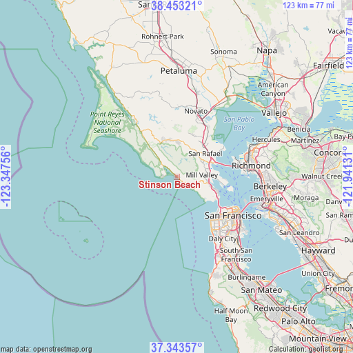
Stinson Beach GPS coordinates[2]
37° 54' 1.728" North, 122° 38' 39.948" West
| Map corner | latitude | longitude |
|---|---|---|
| Upper-left | 38.45321°, | -123.34756° |
| Center: | 37.90048°, | -122.64443° |
| Lower-right: | 37.34357°, | -121.94131° |
| Map W x H: | 123.4×123.4 km | = 76.7×76.7mi |
| max Lat: | 71.29058° ⇑62.2% North |
| Stinson Beach: | 37.90048° |
| min Lat: | ⇓37.8% South 19.06759° |
| min Long | Stinson Beach | max Long |
| -171.73463° | -122.64443° | -66.98998° |
| W 2.9%⇐ | ⇒97.1% E |
Elevation
Elevation of Stinson Beach is 27 m = 89 ft, and this is 267.8 m = 879 ft below average elevation for this country.
| Max E: |
3189 m = 10463 ft | 85.4% |
| Avg. | 294.8 m = 967 ft | |
| Stinson Beach | 27 m = 89 ft | |
Min E: |
-60 m = -197 ft | 14.6% |
See also: United States elevation on elevation.city.
Geographical zone
Stinson Beach is located in North temperate zone (between Tropic of Cancer and the Arctic Circle). Distance of this Northern Tropic circle is 1608.2 km =999.3 mi to South.| Distance of | km | miles | from Stinson Beach |
|---|---|---|---|
| North Pole | 5792.9 | 3599.5 | to North |
| Arctic Circle | 3187 | 1980.3 | to North |
| Tropic Cancer | 1608.2 | 999.3 | to South |
| Equator | 4214.1 | 2618.5 | to South |


Nearby cities:
15 places around Stinson Beach: (largest is in red/bold)
• Alto
10.4 km =6.5 mi,  87°
87°
• Bolinas
3.8 km =2.4 mi,  285°
285°
• Corte Madera
10.6 km =6.6 mi,  74°
74°
• Fairfax
10.8 km =6.7 mi,  26°
26°
• Kentfield
9.6 km =6 mi,  53°
53°
• Larkspur
10.3 km =6.4 mi, 68°
• Marin City
12.4 km =7.7 mi,  106°
106°
• Mill Valley
8.7 km =5.4 mi, 85°
• Ross
10.4 km =6.5 mi, 48°
• San Anselmo
11 km =6.8 mi,  41°
41°
• San Rafael
12.8 km =8 mi, 50°
• Strawberry
11.9 km =7.4 mi, 91°
• Tamalpais Valley
9 km =5.6 mi,  104°
104°
• Tamalpais-Homestead Valley
9.8 km =6.1 mi, 104°
• Woodacre
12.5 km =7.8 mi,  359°
359°
Sources, notices
• [Note1] Compared only with cities in United States existing in our database
• [Src1] Map data: © OpenStreetMap contributors (CC-BY-SA)
• [Src2] Other city data from geonames.org with taken over terms of usage.
• [Src3] Geographical zone / Annual Mean Temperature by Robert A. Rohde @ Wikipedia
