Westlake Village geodata
Westlake Village (California) is a populated place; located in United States in America/Los_Angeles (GMT-7) time zone. With population of 8,507 people, there are 5013 cities with bigger population in this country. Compared to other cities in United States, 79.3% of cities are located further ↑North; 91.8% of cities are located further →East and 70.1% of cities have lower elevation than Westlake Village. Note1


Westlake Village GPS coordinates[2]
34° 8' 45.024" North, 118° 48' 20.34" West
| Map corner | latitude | longitude |
|---|---|---|
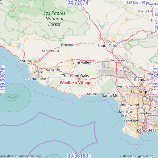
| Upper-left | 34.72574°, | -119.50878° |
| Center: | 34.14584°, | -118.80565° |
| Lower-right: | 33.56193°, | -118.10253° |
| Map W x H: | 129.4×129.4 km | = 80.4×80.4mi |
| max Lat: | 71.29058° ⇑79.3% North |
| Westlake Village: | 34.14584° |
| min Lat: | ⇓20.7% South 19.06759° |
| min Long | Westlake Villag | max Long |
| -171.73463° | -118.80565° | -66.98998° |
| W 8.2%⇐ | ⇒91.8% E |
Elevation
Elevation of Westlake Village is 286 m = 938 ft, and this is 8.8 m = 29 ft below average elevation for this country.
| Max E: |
3189 m = 10463 ft | 29.9% |
| Avg. | 294.8 m = 967 ft | |
| Westlake Village | 286 m = 938 ft | |
Min E: |
-60 m = -197 ft | 70.1% |
See also: United States elevation on elevation.city.
Geographical zone
Westlake Village is located in North temperate zone (between Tropic of Cancer and the Arctic Circle). Distance of this Northern Tropic circle is 1190.7 km =739.9 mi to South.| Distance of | km | miles | from Westlake Village |
|---|---|---|---|
| North Pole | 6210.4 | 3859 | to North |
| Arctic Circle | 3604.5 | 2239.7 | to North |
| Tropic Cancer | 1190.7 | 739.9 | to South |
| Equator | 3796.7 | 2359.2 | to South |


Nearby cities:
15 places around Westlake Village: (largest is in red/bold)
• Agoura
6.2 km =3.9 mi,  92°
92°
• Agoura Hills
3.1 km =1.9 mi,  110°
110°
• Calabasas
15.4 km =9.6 mi, 85°
• Casa Conejo
13.4 km =8.3 mi,  288°
288°
• Hidden Hills
14.2 km =8.8 mi,  83°
83°
• Las Flores
19.8 km =12.3 mi,  127°
127°
• Malibu
13.6 km =8.5 mi,  170°
170°
• Moorpark
17 km =10.6 mi,  335°
335°
• Oak Park
5.4 km =3.4 mi,  46°
46°
• Santa Susana
16.6 km =10.3 mi,  32°
32°
• Simi Valley
13.9 km =8.6 mi,  9°
9°
• Thousand Oaks
4 km =2.5 mi,  313°
313°
• Topanga
19.7 km =12.2 mi, 107°
• West Hills
15.9 km =9.9 mi,  68°
68°
• Woodland Hills
18.5 km =11.5 mi, 82°
Sources, notices
• [Note1] Compared only with cities in United States existing in our database
• [Src1] Map data: © OpenStreetMap contributors (CC-BY-SA)
• [Src2] Other city data from geonames.org with taken over terms of usage.
• [Src3] Geographical zone / Annual Mean Temperature by Robert A. Rohde @ Wikipedia
