Monument geodata
Monument (Colorado) is a populated place; located in United States in America/Denver (GMT-6) time zone. With population of 6,420 people, there are 6164 cities with bigger population in this country. Compared to other cities in United States, 54% of cities are located further ↑North; 83.1% of cities are located further →East and 99.5% of cities have lower elevation than Monument. Note1


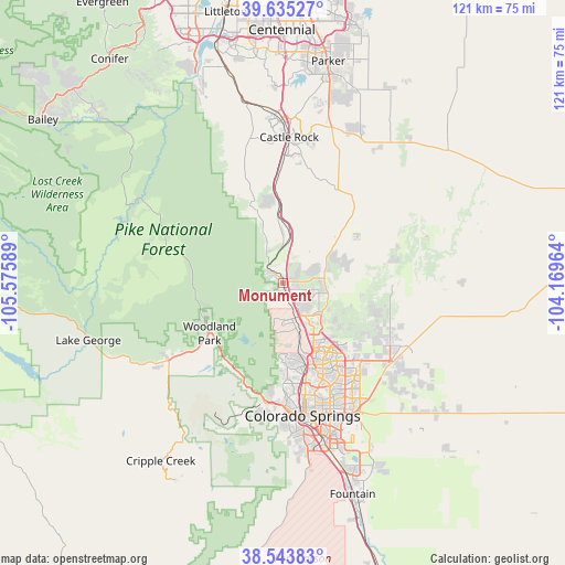
Monument GPS coordinates[2]
39° 5' 29.976" North, 104° 52' 21.936" West
| Map corner | latitude | longitude |
|---|---|---|
| Upper-left | 39.63527°, | -105.57589° |
| Center: | 39.09166°, | -104.87276° |
| Lower-right: | 38.54383°, | -104.16964° |
| Map W x H: | 121.4×121.4 km | = 75.4×75.4mi |
| max Lat: | 71.29058° ⇑54% North |
| Monument: | 39.09166° |
| min Lat: | ⇓46% South 19.06759° |
| min Long | Monument | max Long |
| -171.73463° | -104.87276° | -66.98998° |
| W 16.9%⇐ | ⇒83.1% E |
Elevation
Elevation of Monument is 2132 m = 6995 ft, and this is 1837.2 m = 6028 ft above average elevation for this country.
| Max E: |
3189 m = 10463 ft | 0.5% |
| Monument | 2132 m 6995 ft | |
| Avg. | 294.8 m = 967 ft | |
Min E: |
-60 m = -197 ft | 99.5% |
See also: United States elevation on elevation.city.
Geographical zone
Monument is located in North temperate zone (between Tropic of Cancer and the Arctic Circle). Distance of this Northern Tropic circle is 1740.7 km =1081.6 mi to South.| Distance of | km | miles | from Monument |
|---|---|---|---|
| North Pole | 5660.5 | 3517.3 | to North |
| Arctic Circle | 3054.6 | 1898 | to North |
| Tropic Cancer | 1740.7 | 1081.6 | to South |
| Equator | 4346.6 | 2700.9 | to South |


Nearby cities:
15 places around Monument: (largest is in red/bold)
• Air Force Academy
10.9 km =6.8 mi,  175°
175°
• Black Forest
17.2 km =10.7 mi,  120°
120°
• Cascade-Chipita Park
19.9 km =12.4 mi,  214°
214°
• Castle Rock
31.2 km =19.4 mi,  2°
2°
• Cimarron Hills
30 km =18.6 mi,  149°
149°
• Colorado Springs
29 km =18 mi,  171°
171°
• Elizabeth
38.2 km =23.7 mi,  38°
38°
• Gleneagle
6.6 km =4.1 mi,  141°
141°
• Green Mountain Falls
21.4 km =13.3 mi,  215°
215°
• Manitou Springs
26.1 km =16.2 mi,  188°
188°
• Palmer Lake
5.1 km =3.2 mi,  311°
311°
• Perry Park
21 km =13 mi,  330°
330°
• Stratmoor
36.2 km =22.5 mi, 167°
• Woodland Park
19.3 km =12 mi,  235°
235°
• Woodmoor
2.4 km =1.5 mi,  63°
63°
Sources, notices
• [Note1] Compared only with cities in United States existing in our database
• [Src1] Map data: © OpenStreetMap contributors (CC-BY-SA)
• [Src2] Other city data from geonames.org with taken over terms of usage.
• [Src3] Geographical zone / Annual Mean Temperature by Robert A. Rohde @ Wikipedia
