Perry Park geodata
Perry Park (Colorado) is a populated place; located in United States in America/Denver (GMT-6) time zone. With population of 1,646 people, there are 13104 cities with bigger population in this country. Compared to other cities in United States, 52.6% of cities are located further ↑North; 83.3% of cities are located further →East and 99.1% of cities have lower elevation than Perry Park. Note1


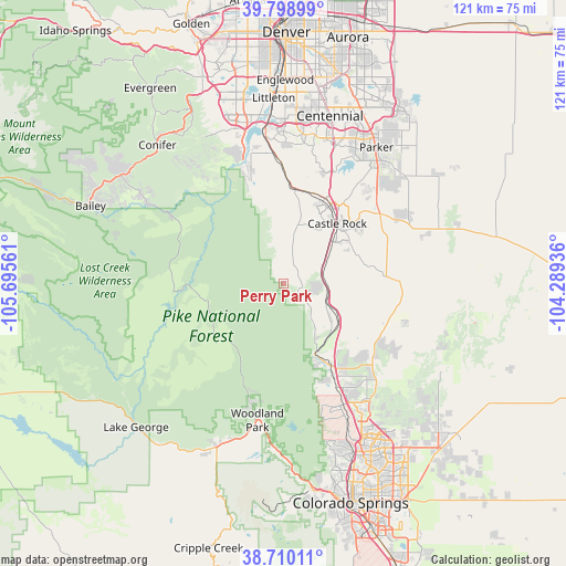
Perry Park GPS coordinates[2]
39° 15' 23.976" North, 104° 59' 32.928" West
| Map corner | latitude | longitude |
|---|---|---|
| Upper-left | 39.79899°, | -105.69561° |
| Center: | 39.25666°, | -104.99248° |
| Lower-right: | 38.71011°, | -104.28936° |
| Map W x H: | 121.1×121.1 km | = 75.2×75.2mi |
| max Lat: | 71.29058° ⇑52.6% North |
| Perry Park: | 39.25666° |
| min Lat: | ⇓47.4% South 19.06759° |
| min Long | Perry Park | max Long |
| -171.73463° | -104.99248° | -66.98998° |
| W 16.7%⇐ | ⇒83.3% E |
Elevation
Elevation of Perry Park is 1982 m = 6503 ft, and this is 1687.2 m = 5535 ft above average elevation for this country.
| Max E: |
3189 m = 10463 ft | 0.90000000000001% |
| Perry Park | 1982 m 6503 ft | |
| Avg. | 294.8 m = 967 ft | |
Min E: |
-60 m = -197 ft | 99.1% |
See also: United States elevation on elevation.city.
Geographical zone
Perry Park is located in North temperate zone (between Tropic of Cancer and the Arctic Circle). Distance of this Northern Tropic circle is 1759 km =1093 mi to South.| Distance of | km | miles | from Perry Park |
|---|---|---|---|
| North Pole | 5642.1 | 3505.8 | to North |
| Arctic Circle | 3036.2 | 1886.6 | to North |
| Tropic Cancer | 1759 | 1093 | to South |
| Equator | 4364.9 | 2712.2 | to South |


Nearby cities:
15 places around Perry Park: (largest is in red/bold)
• Air Force Academy
31.2 km =19.4 mi,  159°
159°
• Carriage Club
31.7 km =19.7 mi,  14°
14°
• Castle Pines
23.9 km =14.9 mi,  20°
20°
• Castle Pines North
25.3 km =15.7 mi, 19°
• Castle Rock
17.4 km =10.8 mi,  42°
42°
• Gleneagle
27.6 km =17.1 mi,  148°
148°
• Heritage Hills
33.3 km =20.7 mi, 17°
• Highlands Ranch
33.1 km =20.6 mi,  3°
3°
• Meridian
33.9 km =21.1 mi, 21°
• Monument
21 km =13 mi, 150°
• Palmer Lake
16.3 km =10.1 mi, 156°
• Roxborough Park
25.4 km =15.8 mi,  341°
341°
• The Pinery
31.3 km =19.4 mi,  45°
45°
• Woodland Park
29.7 km =18.5 mi,  190°
190°
• Woodmoor
21.3 km =13.2 mi,  144°
144°
Sources, notices
• [Note1] Compared only with cities in United States existing in our database
• [Src1] Map data: © OpenStreetMap contributors (CC-BY-SA)
• [Src2] Other city data from geonames.org with taken over terms of usage.
• [Src3] Geographical zone / Annual Mean Temperature by Robert A. Rohde @ Wikipedia
