Parker geodata
Parker (Colorado) is a populated place; located in United States in America/Denver (GMT-6) time zone. With population of 49,550 people, there are 963 cities with bigger population in this country. Compared to other cities in United States, 50.7% of cities are located further ↑North; 83% of cities are located further →East and 98.4% of cities have lower elevation than Parker. Note1


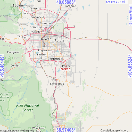
Parker GPS coordinates[2]
39° 31' 6.96" North, 104° 45' 40.896" West
| Map corner | latitude | longitude |
|---|---|---|
| Upper-left | 40.05888°, | -105.46449° |
| Center: | 39.5186°, | -104.76136° |
| Lower-right: | 38.97408°, | -104.05824° |
| Map W x H: | 120.6×120.6 km | = 74.9×74.9mi |
| max Lat: | 71.29058° ⇑50.7% North |
| Parker: | 39.5186° |
| min Lat: | ⇓49.3% South 19.06759° |
| min Long | Parker | max Long |
| -171.73463° | -104.76136° | -66.98998° |
| W 17%⇐ | ⇒83% E |
Elevation
Elevation of Parker is 1795 m = 5889 ft, and this is 1500.2 m = 4922 ft above average elevation for this country.
| Max E: |
3189 m = 10463 ft | 1.6% |
| Parker | 1795 m 5889 ft | |
| Avg. | 294.8 m = 967 ft | |
Min E: |
-60 m = -197 ft | 98.4% |
See also: Parker elevation on elevation.city.
Geographical zone
Parker is located in North temperate zone (between Tropic of Cancer and the Arctic Circle). Distance of this Northern Tropic circle is 1788.1 km =1111.1 mi to South.| Distance of | km | miles | from Parker |
|---|---|---|---|
| North Pole | 5613 | 3487.8 | to North |
| Arctic Circle | 3007.1 | 1868.5 | to North |
| Tropic Cancer | 1788.1 | 1111.1 | to South |
| Equator | 4394.1 | 2730.4 | to South |


Nearby cities:
15 places around Parker: (largest is in red/bold)
• Acres Green
12.3 km =7.6 mi,  290°
290°
• Carriage Club
12.1 km =7.5 mi,  277°
277°
• Castle Pines
13.4 km =8.3 mi,  239°
239°
• Castle Pines North
12.6 km =7.8 mi,  245°
245°
• Centennial
12 km =7.5 mi,  304°
304°
• Cottonwood
6 km =3.7 mi,  324°
324°
• Dove Valley
8.8 km =5.5 mi, 318°
• Foxfield
8.6 km =5.3 mi,  341°
341°
• Grand View Estates
5.8 km =3.6 mi, 298°
• Heritage Hills
10.4 km =6.5 mi, 285°
• Inverness
10.8 km =6.7 mi,  307°
307°
• Lone Tree
11.3 km =7 mi, 288°
• Meridian
7.6 km =4.7 mi, 287°
• Stonegate
3.9 km =2.4 mi, 290°
• The Pinery
7.4 km =4.6 mi,  161°
161°
Sources, notices
• [Note1] Compared only with cities in United States existing in our database
• [Src1] Map data: © OpenStreetMap contributors (CC-BY-SA)
• [Src2] Other city data from geonames.org with taken over terms of usage.
• [Src3] Geographical zone / Annual Mean Temperature by Robert A. Rohde @ Wikipedia
